IMAGES TAKEN NEAR TO
The Street, BRISTOL, BS40 6EA
Introduction
This page details the photographs taken nearby to The Street, BS40 6EA by members of the Geograph project.
The Geograph project started in 2005 with the aim of publishing, organising and preserving representative images for every square kilometre of Great Britain, Ireland and the Isle of Man.

There are currently over 7.5m images from over14,400 individuals and you can help contribute to the project by visiting https://www.geograph.org.uk
Image Map (Loading...)


Getting Data...Please wait
Leaflet Map data © OpenStreetMap
Images are licensed for reuse under creativecommons.org/licenses/by-sa/2.0
Notes
- Clicking on the map will re-center to the selected point.
- The higher the marker number, the further away the image location is from the centre of the postcode.
Image Listing (87 Images Found)
Images are licensed for reuse under creativecommons.org/licenses/by-sa/2.0
Image
Details
Distance
1
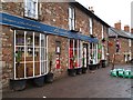
Shop and Post Office
Bowdens of Harptree.
Stopped off at this shop while on a cycle ride around Chew Valley Lake, purchased some freshly made rolls, staff friendly, rolls delicious!
Image: © Chris McAuley
Taken: 17 Feb 2010
0.01 miles
2
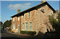
Houses, West Harptree
A pair of semis on The Street (the A368).
Image: © Derek Harper
Taken: 27 Feb 2022
0.01 miles
3
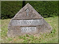
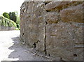
Millennium stone
As with so many villages a stone sign greets visitors, dated either in Roman numerals or contemporary like this one.
Image: © Neil Owen
Taken: 3 Jun 2013
0.01 miles
4
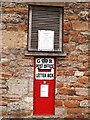
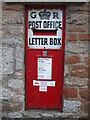
Letter Box
A 'Ludlow'Post Office Letter Box, in the wall of West Harptree Sub Post Office. (George V 1910-1936)
http://www.cvphm.org/LudlowTour.html
Image: © Chris McAuley
Taken: 17 Feb 2010
0.01 miles
5
Priority over the weekend
West Harptree's enamelled letterbox, now a priority box in these Covid days.
Image: © Neil Owen
Taken: 29 Apr 2021
0.02 miles
6
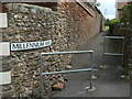
Millennium Way
A short alley to the play area at the back of West Harptree. The path itself is many years old, though.
Image: © Neil Owen
Taken: 29 Apr 2021
0.02 miles
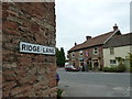
7
East Harptree Road benchmark
Leading from the junction at the east end of West Harptree is this cutmark; see http://www.bench-marks.org.uk/bm48856 for the entry in the Benchmark Database.
Image: © Neil Owen
Taken: 3 Jun 2013
0.02 miles
8
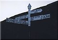
Direction Sign - Signpost on the A368 in West Harptree
Pyramid finial - 4 arms; Somerset SCC pyramid by the A368, in parish of West Harptree (Bath And North East Somerset District), on the north side of the junction of the A368 The Street with Whistley Lane and East Harptree Road.
surveyed
Milestone Society National ID: SO_ST5656C
Image: © Milestone Society
Taken: Unknown
0.02 miles
9
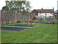
West Harptree play area
An outdoor set of equipment, set back from the main road.
Image: © Neil Owen
Taken: 29 Apr 2021
0.03 miles
10
Three off the leash on the Limestone Link (123)
In which three middle aged men who have known each other for forty years embark on an intrepid yomp across a path that links the Cotswold Way with the West Mendip Way http://en.wikipedia.org/wiki/Limestone_Link
Image: © Basher Eyre
Taken: 15 Sep 2012
0.03 miles