IMAGES TAKEN NEAR TO
Western Lane, BRISTOL, BS40 6DL
Introduction
This page details the photographs taken nearby to Western Lane, BS40 6DL by members of the Geograph project.
The Geograph project started in 2005 with the aim of publishing, organising and preserving representative images for every square kilometre of Great Britain, Ireland and the Isle of Man.

There are currently over 7.5m images from over14,400 individuals and you can help contribute to the project by visiting https://www.geograph.org.uk
Image Map
Images are licensed for reuse under creativecommons.org/licenses/by-sa/2.0
Notes
- Clicking on the map will re-center to the selected point.
- The higher the marker number, the further away the image location is from the centre of the postcode.
Image Listing (9 Images Found)
Images are licensed for reuse under creativecommons.org/licenses/by-sa/2.0
Image
Details
Distance
2
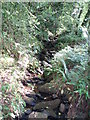
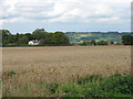
Molly Brook
This small brook descends rapidly through Harptree combe (this is at the top end of the combe) and eventually runs into Chew Valley lake.
Image: © Sharon Loxton
Taken: 24 Jun 2006
0.07 miles
4
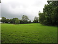
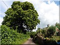
The Monarch's Way heads uphill
A Right of Way, indistinct here, forms part of the Monarch's Way Long Distance Path which is 610 miles in total! At this point it climbs more steeply than the photo might suggest.
Image: © David Purchase
Taken: 24 Aug 2011
0.13 miles
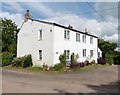
5
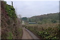
Following Western Lane down to Garrow Bottom
Image: © Tim Heaton
Taken: 11 Feb 2015
0.18 miles
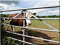
7
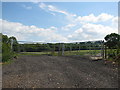
Double gates into field near East Harptree
Image: © Sarah Charlesworth
Taken: 16 Aug 2010
0.20 miles
8
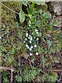
Snowdrops on a wall
Snowdrops growing on a drystone wall beside Smitham Hill, north of East Harptree.
Image: © Kevin Pearson
Taken: 12 Feb 2022
0.21 miles