IMAGES TAKEN NEAR TO
Wrington Hill, BRISTOL, BS40 5PW
Introduction
This page details the photographs taken nearby to Wrington Hill, BS40 5PW by members of the Geograph project.
The Geograph project started in 2005 with the aim of publishing, organising and preserving representative images for every square kilometre of Great Britain, Ireland and the Isle of Man.

There are currently over 7.5m images from over14,400 individuals and you can help contribute to the project by visiting https://www.geograph.org.uk
Image Map (Loading...)


Getting Data...Please wait
Leaflet Map data © OpenStreetMap
Images are licensed for reuse under creativecommons.org/licenses/by-sa/2.0
Notes
- Clicking on the map will re-center to the selected point.
- The higher the marker number, the further away the image location is from the centre of the postcode.
Image Listing (32 Images Found)
Images are licensed for reuse under creativecommons.org/licenses/by-sa/2.0
Image
Details
Distance
1
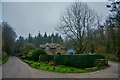
Congresbury : Wrington Hill
Looking along the road with the entrance to Wooside Cottage on the right.
Image: © Lewis Clarke
Taken: 24 Jan 2022
0.01 miles
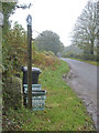
2
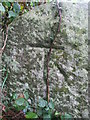
Ordnance Survey Cut Mark
This OS cut mark can be found on the Boundary Stone west side of the road. It marks a point 136.422m above mean sea level.
Image: © Adrian Dust
Taken: 25 Jul 2022
0.02 miles
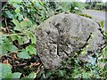
3
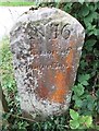
Benchmark on boundary stone number 16
On the reverse side of the boundary stone on Wrington Hill is a cutmark. See Image] for a wider view, Image] for a look at the front of the stone or https://www.bench-marks.org.uk/bm63859 for the entry in the Benchmark Database.
Image: © Neil Owen
Taken: 31 Oct 2019
0.02 miles
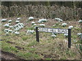
4
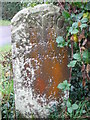
Boundary Stone number 16
Number 16 lies on Wrington Hill, where the woodland boundary is partly isected by the road. See Image] for a look at the opposite side where a benchmark can be found.
Image: © Neil Owen
Taken: 31 Oct 2019
0.02 miles
5
Boundary stone opposite Cleeve Hill Farm
One of many in this part of the woodlands, the stone is on Wrington Hill road. Recycling boxes from Woolmers Farm stand here, despite the farm being a long walk into the woods.
See Image] for a look at the stone.
Image: © Neil Owen
Taken: 31 Oct 2019
0.02 miles
6
Hedge and Bank in Cleeve Hill Road with snowdrops
Image: © Dr Duncan Pepper
Taken: 20 Feb 2009
0.02 miles
7
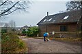
Congresbury : Woodside Cottage
Passing Woodside Cottage on the track.
Image: © Lewis Clarke
Taken: 24 Jan 2022
0.02 miles
9
Old Boundary Marker by Cleeve Hill Road, Congresbury parish
Estate Boundary Marker by the UC road, in parish of Congresbury (North Somerset District), Cleeve Hill Road, West side of road, by entrance to Woolmers.
Inscription reads:-
N.16
Manor of
Congresbury
Grade II listed.
List Entry Number: 1129205 https://historicengland.org.uk/listing/the-list/list-entry/1129205
To be surveyed
Milestone Society National ID: SO_CONGRE16em
Image: © Milestone Society
Taken: Unknown
0.02 miles
10
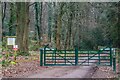
Congresbury : Track
A gate and track at the entrance to the woods.
Image: © Lewis Clarke
Taken: 24 Jan 2022
0.04 miles