IMAGES TAKEN NEAR TO
Langford Road, BRISTOL, BS40 5HY
Introduction
This page details the photographs taken nearby to Langford Road, BS40 5HY by members of the Geograph project.
The Geograph project started in 2005 with the aim of publishing, organising and preserving representative images for every square kilometre of Great Britain, Ireland and the Isle of Man.

There are currently over 7.5m images from over14,400 individuals and you can help contribute to the project by visiting https://www.geograph.org.uk
Image Map
Images are licensed for reuse under creativecommons.org/licenses/by-sa/2.0
Notes
- Clicking on the map will re-center to the selected point.
- The higher the marker number, the further away the image location is from the centre of the postcode.
Image Listing (27 Images Found)
Images are licensed for reuse under creativecommons.org/licenses/by-sa/2.0
Image
Details
Distance
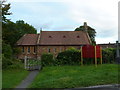
1
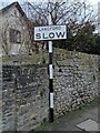
Village Signpost on Langford Road, Lower Langford
Located in Lower Langford, on the north side of Langford Road, against the front garden wall of Park House. Churchill parish.
Milestone Society National ID: SO_ST4660V
Image: © Roadside Relics
Taken: 19 Feb 2019
0.14 miles
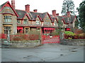
4
University of Bristol Veterinary School , Langford
For more information see the Veterinary School's website http://www.vetschool.bris.ac.uk/
Image: © FollowMeChaps
Taken: 2 Jan 2006
0.17 miles
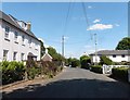
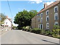
5
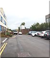
The Dolberry Building
This fairly new building, seen on the left, is part of the Langford Campus of Bristol University’s Veterinary School and houses various research projects. The campus is the location of a great deal of animal research and visitors are warned that dead animals may be in view as they are shown round.
Image: © HelenK
Taken: 20 Sep 2018
0.19 miles
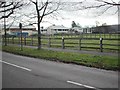
6
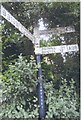
Direction Sign - Signpost by the B3133 in Langford
Pyramid finial - 3 arms; Somerset SCC pyramid by the B3133, in parish of Churchill (North Somerset District), Langford Road junction with Stock Lane, West end of Lower Langford.
Surveyed
Milestone Society National ID: SO_ST4560
Image: © Milestone Society
Taken: Unknown
0.19 miles