IMAGES TAKEN NEAR TO
Laurel Drive, BRISTOL, BS39 7RT
Introduction
This page details the photographs taken nearby to Laurel Drive, BS39 7RT by members of the Geograph project.
The Geograph project started in 2005 with the aim of publishing, organising and preserving representative images for every square kilometre of Great Britain, Ireland and the Isle of Man.

There are currently over 7.5m images from over14,400 individuals and you can help contribute to the project by visiting https://www.geograph.org.uk
Image Map (Loading...)


Getting Data...Please wait
Leaflet Map data © OpenStreetMap
Images are licensed for reuse under creativecommons.org/licenses/by-sa/2.0
Notes
- Clicking on the map will re-center to the selected point.
- The higher the marker number, the further away the image location is from the centre of the postcode.
Image Listing (54 Images Found)
Images are licensed for reuse under creativecommons.org/licenses/by-sa/2.0
Image
Details
Distance
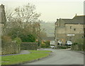
1
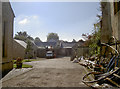
The builders are back in
This little piece of land beside Holy Trinity has seen plenty of building work, and thereafter demolition. Once this held a scattering of nineteenth century houses, outhouses and assorted school rooms. Later, it became the site where Somerville Comprehensive School founded an annexe in 1931; that closed in 1957. It then became a builder's yard from 1980 until 2007. Now the cement mixers are churning again, creating a residential area.
Image: © Neil Owen
Taken: 11 Oct 2016
0.04 miles
2
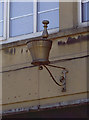
A mortar and pestle?
This emblem hangs outside a shop on The Pithay. Today it is a food takeaway (see Image]), but this suggests it was previously a pharmacy.
Image: © Neil Owen
Taken: 11 Oct 2016
0.05 miles
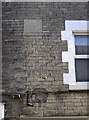
3
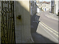
Benchmark by the gate
A modern (post-WWII) cutmark on the corner of a shop in the Pithay, as listed in the Benchmark Database: http://www.bench-marks.org.uk/bm79632 . It replaces an older mark on the other side of the road that was lost. See Image] for a look at the shop.
Image: © Neil Owen
Taken: 11 Oct 2016
0.05 miles
4
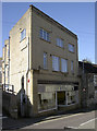
Eve's Kitchen
A fairly modern shop building in the Pithay, now a food outlet. However, the shop also has an emblem hanging above it that gives witness to its past - see Image
Image: © Neil Owen
Taken: 11 Oct 2016
0.05 miles
5
2008 : Park Road, Paulton
Copied from Wikipedia, the free encyclopedia
Paulton is a large village, population around 5,000, located to the north of the Mendip Hills, in the unitary authority of Bath and North East Somerset (BANES), England. A former coal mining village and home to the now-closed Polestar Purnells printing factory and Ashman's boot factory, where 'Tuf' boots were manufactured, Paulton is now largely populated by commuters to Bristol and Bath.
Image: © Maurice Pullin
Taken: 19 Dec 2008
0.05 miles
6

School art in public
A gateway is draped with a sheet created by Paulton Infant School; the tree is adorned with lots of handprints for leaves.
Image: © Neil Owen
Taken: 11 Oct 2016
0.05 miles
7
The Lamb Inn, Paulton
An old inn, probably host to hundreds of miners and printers in its time.
Image: © Neil Owen
Taken: 11 Oct 2016
0.05 miles
9
A datestone and a fossil
Some interesting clash of dates in The Pithay.
Image: © Neil Owen
Taken: 11 Oct 2016
0.06 miles
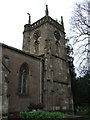
10
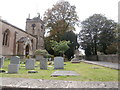
Holy Trinity, Paulton
Holy Trinity is one of three churches in the Paulton Benefice https://paulton-benefice.org.uk/. The church as it is now is largely the result of restoration by John Pinch the Younger. The clock face is unusually elaborate, with an ironwork pattern.
Image: © HelenK
Taken: 30 Sep 2018
0.06 miles