IMAGES TAKEN NEAR TO
High Street, BRISTOL, BS39 7NW
Introduction
This page details the photographs taken nearby to High Street, BS39 7NW by members of the Geograph project.
The Geograph project started in 2005 with the aim of publishing, organising and preserving representative images for every square kilometre of Great Britain, Ireland and the Isle of Man.

There are currently over 7.5m images from over14,400 individuals and you can help contribute to the project by visiting https://www.geograph.org.uk
Image Map (Loading...)


Getting Data...Please wait
Leaflet Map data © OpenStreetMap
Images are licensed for reuse under creativecommons.org/licenses/by-sa/2.0
Notes
- Clicking on the map will re-center to the selected point.
- The higher the marker number, the further away the image location is from the centre of the postcode.
Image Listing (52 Images Found)
Images are licensed for reuse under creativecommons.org/licenses/by-sa/2.0
Image
Details
Distance
1
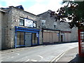
Closed Shops in Paulton
These shops on the Bath Road, a baker, a betting shop and a pine furniture shop have all closed. They occupy some old stone buildings. There are sold signs on two of them so perhaps the site will be developed.
Image: © Nigel Mykura
Taken: 18 Sep 2011
0.01 miles
2
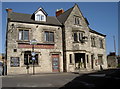
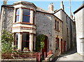
The Red Lion, Paulton
Occupying a prime site at the top of town. See Image] for a detail.
Image: © Neil Owen
Taken: 11 Oct 2016
0.03 miles
3
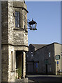
A guiding light for the thirsty
The ornate light outside the Red Lion. See Image] for a fuller view.
Image: © Neil Owen
Taken: 11 Oct 2016
0.03 miles
4
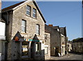
Paulton Post Office
The office appears to have served the community since the early twentieth century. You can even get your coat dry cleaned, too.
Image: © Neil Owen
Taken: 11 Oct 2016
0.04 miles
5
A better old name
This very short lane between The Pithay and Church Street is called Church Lane. However, the sign also tells of its previous name - Candlegrease Lane.
Image: © Neil Owen
Taken: 11 Oct 2016
0.05 miles
6
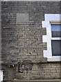
A datestone and a fossil
Some interesting clash of dates in The Pithay.
Image: © Neil Owen
Taken: 11 Oct 2016
0.06 miles
7
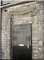
Parochial School door
This doorway, close to Holy Trinity church, is largely all that remains of the old school rooms. Education in Paulton seems to have expanded greatly in the latter part of the nineteenth century, but this one has been extensively converted into dwellings. See Image] for a wider view.
Image: © Neil Owen
Taken: 11 Oct 2016
0.07 miles
8
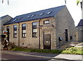
School days of the past
This is the old Parochial School, nowadays a private residential conversion. See Image] for a detail.
Image: © Neil Owen
Taken: 11 Oct 2016
0.07 miles
9
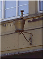
A mortar and pestle?
This emblem hangs outside a shop on The Pithay. Today it is a food takeaway (see Image]), but this suggests it was previously a pharmacy.
Image: © Neil Owen
Taken: 11 Oct 2016
0.07 miles
10
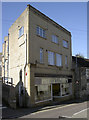
Eve's Kitchen
A fairly modern shop building in the Pithay, now a food outlet. However, the shop also has an emblem hanging above it that gives witness to its past - see Image
Image: © Neil Owen
Taken: 11 Oct 2016
0.07 miles