IMAGES TAKEN NEAR TO
Bath Road, BRISTOL, BS39 7BB
Introduction
This page details the photographs taken nearby to Bath Road, BS39 7BB by members of the Geograph project.
The Geograph project started in 2005 with the aim of publishing, organising and preserving representative images for every square kilometre of Great Britain, Ireland and the Isle of Man.

There are currently over 7.5m images from over14,400 individuals and you can help contribute to the project by visiting https://www.geograph.org.uk
Image Map (Loading...)


Getting Data...Please wait
Leaflet Map data © OpenStreetMap
Images are licensed for reuse under creativecommons.org/licenses/by-sa/2.0
Notes
- Clicking on the map will re-center to the selected point.
- The higher the marker number, the further away the image location is from the centre of the postcode.
Image Listing (10 Images Found)
Images are licensed for reuse under creativecommons.org/licenses/by-sa/2.0
Image
Details
Distance
1
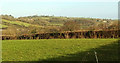
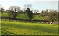
Field near Somerset Inn
The former Somerset Inn, I think that is. This looks right from Image], again towards and across the Cam Brook valley.
Image: © Derek Harper
Taken: 9 Dec 2019
0.02 miles
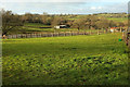
2
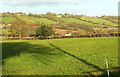
Towards the Cam Brook valley
Looking right from Image], with Timsbury on the horizon.
Image: © Derek Harper
Taken: 9 Dec 2019
0.05 miles
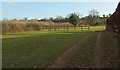
3
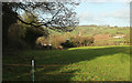
Towards the Cam Brook valley
From a gateway on the Bath Road on the northeast edge of Paulton.
Image: © Derek Harper
Taken: 9 Dec 2019
0.06 miles
4
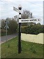
Direction Sign ? Signpost
Located on the southeast side of the crossroads of Bath Road and Brittens Hill in Paulton parish. 3 arms and pyramid finial.
Milestone Society National ID: SO_ST6556A
Image: © D Edwards
Taken: 9 Aug 2020
0.09 miles
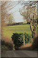
6
Private track, Lyndon Vale
Leading away from the Bath Road.
Image: © Derek Harper
Taken: 9 Dec 2019
0.15 miles
7
Cam Brook valley
Looking right from Image], with overlap. On the right is the rebuilt Paulton Engine House shown in Image
Image: © Derek Harper
Taken: 9 Dec 2019
0.19 miles
9
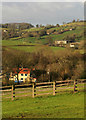
Cam Brook valley
Seen from near Withy Barn. The conspicuous red roof is at the "recently rebuilt Paulton Engine House ... created from the ruins of the Paulton Iron & Brass Foundry" https://sites.google.com/site/paultonhistory/paulton-history-walk . At top right is a wind turbine on The Sleight (in Image) above Timsbury.
Image: © Derek Harper
Taken: 9 Dec 2019
0.23 miles
10
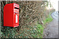
Postbox at Withy Mills
Elizabethan II postbox BS39 395 is on Bath Road close to the right of the camera in Image
Image: © Derek Harper
Taken: 9 Dec 2019
0.23 miles