IMAGES TAKEN NEAR TO
Greyfield Road, BRISTOL, BS39 6XX
Introduction
This page details the photographs taken nearby to Greyfield Road, BS39 6XX by members of the Geograph project.
The Geograph project started in 2005 with the aim of publishing, organising and preserving representative images for every square kilometre of Great Britain, Ireland and the Isle of Man.

There are currently over 7.5m images from over14,400 individuals and you can help contribute to the project by visiting https://www.geograph.org.uk
Image Map
Images are licensed for reuse under creativecommons.org/licenses/by-sa/2.0
Notes
- Clicking on the map will re-center to the selected point.
- The higher the marker number, the further away the image location is from the centre of the postcode.
Image Listing (26 Images Found)
Images are licensed for reuse under creativecommons.org/licenses/by-sa/2.0
Image
Details
Distance
1
Scumbrum Lane
Simply had to include this street name. Interestingly, older maps refer to it as Scumbrom Lane. The chevrons have rather lost their impact, though.
Image: © Neil Owen
Taken: 6 Oct 2016
0.05 miles
2
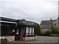
Haynes restaurant (fish and chips)
Another view in Image
Image: © David Smith
Taken: 10 Jun 2017
0.05 miles
3
Haynes fish and chip restaurant
High Littleton is blessed to have a fine establishment. There has been a chippy here for many years (known as The Hut) before the Haynes family took it over in 1955. Fish landed at Grimsby was sent by steam train to Hallatrow station overnight so that the freshness would be maintained. In 1988 the shop was expanded to become a restaurant, seating 44.
Image: © Neil Owen
Taken: 6 Oct 2016
0.06 miles
4
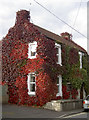
Crimson gown
A cottage on New Road wears a full range of Autumn colour.
Image: © Neil Owen
Taken: 6 Oct 2016
0.06 miles
5
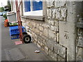
Benchmark on Dando's
An old benchmark on a shop in High Littleton, as listed in the Benchmark Database: http://www.bench-marks.org.uk/bm79463 . Also see Image] for a wider view.
Image: © Neil Owen
Taken: 6 Oct 2016
0.07 miles
6
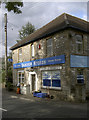
Dando's Store
At the top end of High Littleton and offering a variety of goods. See Image] for a benchmark on the corner.
Image: © Neil Owen
Taken: 6 Oct 2016
0.07 miles
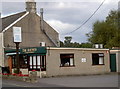
7
The Haynes restaurant
Fish and chips to eat in or take away http://thehaynes.co.uk/ . This establishment is popular, and in the evenings locals can be seen chatting inside as they wait to collect their order.
Image: © HelenK
Taken: 8 Jul 2014
0.07 miles
8
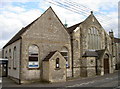
Church centre
High Littleton was a village that grew rapidly with the local coal mining industry. As with many in a similar boom, many villagers became committed with the Methodist movement. This is the northernmost of the chapels and it also offered Sunday schooling. It has now joined forces with the Holy Trinity Anglican Church to provide many varied community facilities.
Image: © Neil Owen
Taken: 6 Oct 2016
0.11 miles
9
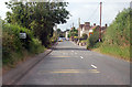
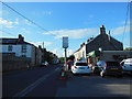
Entering High Littleton on A39
A 30 MPH limit is in place.
Image: © J.Hannan-Briggs
Taken: 31 Jul 2014
0.11 miles
10
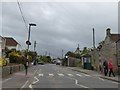
Pedestrian crossing, High Street, High Littleton
Image: © David Smith
Taken: 10 Jun 2017
0.12 miles