IMAGES TAKEN NEAR TO
Butlass Close, BRISTOL, BS39 6HD
Introduction
This page details the photographs taken nearby to Butlass Close, BS39 6HD by members of the Geograph project.
The Geograph project started in 2005 with the aim of publishing, organising and preserving representative images for every square kilometre of Great Britain, Ireland and the Isle of Man.

There are currently over 7.5m images from over14,400 individuals and you can help contribute to the project by visiting https://www.geograph.org.uk
Image Map (Loading...)


Getting Data...Please wait
Leaflet Map data © OpenStreetMap
Images are licensed for reuse under creativecommons.org/licenses/by-sa/2.0
Notes
- Clicking on the map will re-center to the selected point.
- The higher the marker number, the further away the image location is from the centre of the postcode.
Image Listing (44 Images Found)
Images are licensed for reuse under creativecommons.org/licenses/by-sa/2.0
Image
Details
Distance
1
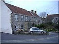
The Market Tavern, High Littleton
Converted to a dwelling.
Image: © Roger Cornfoot
Taken: 12 Mar 2007
0.03 miles
2
2008 : The Batch, High Littleton
A batch is the North Somerset coalfield name for a slag heap, there would have been one near here, possibly still is.
The following was copied from: http://www.highlittleton.org.uk/Parish%20Council%20Web/history.html
High Littleton was probably settled by the Saxons in the late 7th or 8th century. They called it Lytel tun.
The parish would have some of the earliest of the Somerset coal mines because here the coal seams ran obliquely to the surface. The first documentary evidence of mining in the parish dates from 1633 and the first deep mine in the parish was Mearns Coalworks which began in 1783. The wealth and work generated by the mines attracted people in and by 1800 the population had grown to about 800. In fact, production at these pits did not last very long and by 1820 most of the miners who lived in the parish worked in neighbouring villages. The Greyfield Coal Company did not start until 1833 and was at that time outside the parish. It received a boost with the opening of the railway in 1873. Greyfield Colliery closed in 1911 and the railway in 1964.
Image: © Maurice Pullin
Taken: 20 Sep 2008
0.04 miles
3
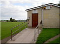
High Littleton Recreation Club
The recreation ground is getting on for a century old and the village has a number of clubs based here, including the recently-returned football club, skittles clubs and the flying club. The latter involves pigeons, incidentally.
Image: © Neil Owen
Taken: 6 Oct 2016
0.05 miles
4
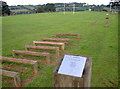
The Hurdles
Improve your speed, agility and quickness! High Littleton's recreation ground has a multi-station outdoor fitness trail around the football pitch.
Image: © Neil Owen
Taken: 6 Oct 2016
0.05 miles
5
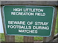
Beware of footballs!
This warning sign is, oddly, on the inside of the gate to the children's play area, where you'd only see it on leaving.
Image: © Neil Owen
Taken: 6 Oct 2016
0.05 miles
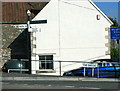
6
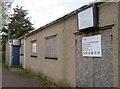
Closed ranks
The British Legion building in High Littleton seems to have been shut up.
Image: © Neil Owen
Taken: 6 Oct 2016
0.05 miles
7
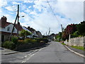
Houses on Timsbury Rd
View up Timsbury Rd towards its junction with the A39. The road coming in on the left is The Batch leading on to Goosard Lane.
Image: © Nigel Mykura
Taken: 18 Sep 2011
0.05 miles
8
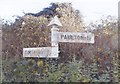
Old Direction Sign - Signpost by Timsbury Road, High Littleton
Pyramid finial - 2 arms; Somerset SCC pyramid by the A39, in parish of High Littleton (Bath and North East Somerset District), Timsbury Road junction with The Batch.
Surveyed
Milestone Society National ID: SO_ST6458A
Image: © Milestone Society
Taken: Unknown
0.06 miles
9
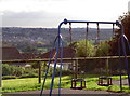
Play area with a view
The village of Paulton is visible from High Littleton's recreation ground.
Image: © Neil Owen
Taken: 6 Oct 2016
0.06 miles
10

High Littleton play area
A nice and modern play area for the young ones, with nice views over the hillside. However, its location behind one goal leads to a problem - see Image
Image: © Neil Owen
Taken: 6 Oct 2016
0.06 miles