IMAGES TAKEN NEAR TO
Hillside Gardens, BRISTOL, BS39 5XG
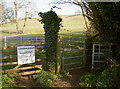
Introduction
This page details the photographs taken nearby to Hillside Gardens, BS39 5XG by members of the Geograph project.
The Geograph project started in 2005 with the aim of publishing, organising and preserving representative images for every square kilometre of Great Britain, Ireland and the Isle of Man.

There are currently over 7.5m images from over14,400 individuals and you can help contribute to the project by visiting https://www.geograph.org.uk
Image Map
Images are licensed for reuse under creativecommons.org/licenses/by-sa/2.0
Notes
- Clicking on the map will re-center to the selected point.
- The higher the marker number, the further away the image location is from the centre of the postcode.
Image Listing (71 Images Found)
Images are licensed for reuse under creativecommons.org/licenses/by-sa/2.0
Image
Details
Distance
1
Livestock in field
A warning sign to all users that travel along the footings of Burledge Hill.
Image: © Neil Owen
Taken: 17 Mar 2016
0.04 miles
2
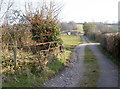
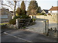
Turning left
The official footpath bears left here, leaving the track to private property.
Image: © Neil Owen
Taken: 17 Mar 2016
0.06 miles
3
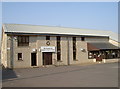
Bishop Sutton village hall
This modern version was built around the millennium and replaces an earlier hall on this site.
Image: © Neil Owen
Taken: 17 Mar 2016
0.07 miles
4
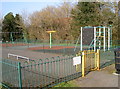
Something for all
A play area at the rear of the village hall, offering equipment and skateboard facilities.
Image: © Neil Owen
Taken: 17 Mar 2016
0.08 miles
5
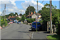
2012 : A368 Roadworks on Wick Road, Bishop Sutton
In the introduction to their website Bishop Sutton says "This website was created to provide information to local residents, and those over the hill"
Well that's me. In spite of this I give you a link to and a quote from an interesting village website http://www.bishopsutton.org.uk/about-the-village/
"Bishop Sutton is a small village within the Chew Valley in NE Somerset. It lies south of Chew Valley Lake and north of the Mendip Hills, approximately ten miles south of Bristol on the A368, Weston-super-Mare to Bath road. Bishop Sutton and the neighbouring village of Stowey form the civil parish of Stowey Sutton."
Image: © Maurice Pullin
Taken: 20 Aug 2012
0.10 miles
6
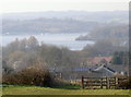
The lake in the haze
Spring sunshine in March inevitably brings some increased humidity and haze. The view from the hills above Bishop Sutton over to Chew Valley Lake are none the less attractive for it, though.
Image: © Neil Owen
Taken: 17 Mar 2016
0.10 miles
7
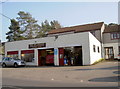
Old Pit Garage
This modern building fronts what used to be a coal pit, hence the name. The village of Bishop Sutton lies just on the western fringe of the Somerset Coalfields and extraction is believed to have started in the early eighteenth century. The large woodland behind this garage was the location for a pit, although it was not the largest - they were at the other end of the village. Coal production was dwindling by the twentieth century and closed down.
Image: © Neil Owen
Taken: 17 Mar 2016
0.12 miles
8
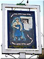
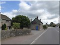
Sign for the Butchers Arms
The Butchers Company was granted arms in 1540 although this sign has a more pictorial image.
Image: © Maigheach-gheal
Taken: 17 Jan 2010
0.12 miles
9
Walk through the drive
A footpath appears to take the route through someone's private driveway. The path links up with Stitchings Shord Lane.
Image: © Neil Owen
Taken: 17 Mar 2016
0.12 miles
10
The Sutton Spice restaurant, Bishop Sutton
Former inn Image now restaurant and takeaway
Image: © David Smith
Taken: 7 Jul 2016
0.13 miles