IMAGES TAKEN NEAR TO
Bonhill Lane, BRISTOL, BS39 5TU
Introduction
This page details the photographs taken nearby to Bonhill Lane, BS39 5TU by members of the Geograph project.
The Geograph project started in 2005 with the aim of publishing, organising and preserving representative images for every square kilometre of Great Britain, Ireland and the Isle of Man.

There are currently over 7.5m images from over14,400 individuals and you can help contribute to the project by visiting https://www.geograph.org.uk
Image Map (Loading...)


Getting Data...Please wait
Leaflet Map data © OpenStreetMap
Images are licensed for reuse under creativecommons.org/licenses/by-sa/2.0
Notes
- Clicking on the map will re-center to the selected point.
- The higher the marker number, the further away the image location is from the centre of the postcode.
Image Listing (21 Images Found)
Images are licensed for reuse under creativecommons.org/licenses/by-sa/2.0
Image
Details
Distance
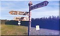
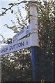
1
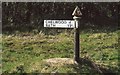
Old Direction Sign - Signpost by Bonhill Road, Stowey Sutton Parish
Pyramid finial - 1 arm; Somerset SCC pyramid by the UC road, in parish of Stowey Sutton (Bath and North East Somerset District), Bonhill Road, North end, Bishop Sutton.
Surveyed
Milestone Society National ID: SO_ST5860B
Image: © Milestone Society
Taken: Unknown
0.01 miles
2
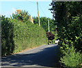
2012 : Minor road to Bishop Sutton
From Chew Stoke.
About half a mile along Bonhill Road to the A368.
Image: © Maurice Pullin
Taken: 20 Aug 2012
0.01 miles
3
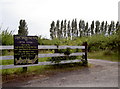
Entrance to Chew Valley Fruit Farm
Lots of different produce on offer here, although it's simply marked with the orchard symbol on the map.
Image: © Neil Owen
Taken: 11 Jul 2010
0.05 miles
4
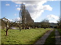
Wassailed and waiting
An orchard looks pretty bare at this time of year, but the work is clearly being carried out in other departments.
Image: © Neil Owen
Taken: 7 Mar 2016
0.06 miles
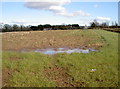
5

2012 : Pasture north of Bonhill Road
Whitegates is to the right.
Image: © Maurice Pullin
Taken: 20 Aug 2012
0.06 miles
6
2012 : Corner of an orchard near Bishop Sutton
Looks like cider apples. Should have tasted one.
Image: © Maurice Pullin
Taken: 20 Aug 2012
0.09 miles
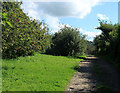
7
Field west of Whitegates
Bearing the marks of crop remnants and some recent wet weather. Bonhill Lane runs along in the background, with Whitegates house in the centre. The building is a fairly modern one, being built in the twentieth century.
Image: © Neil Owen
Taken: 7 Mar 2016
0.14 miles
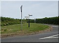
8
Old Direction Sign - Signpost by Walley Lane, Stowey Sutton parish
Pyramid finial - 3 arms; Somerset SCC pyramid by the UC road, in parish of Stowey Sutton (Bath and North East Somerset District), Walley Lane, junction with Hollowbrook Lane and Ham Lane, at Hollow Brook, opposite Denny Island.
Surveyed
Milestone Society National ID: SO_ST5860A
Image: © Milestone Society
Taken: Unknown
0.16 miles
10
Direction Sign - Signpost at the junction of Hollowbrook Lane and Ham Lane
Pyramid finial - 2 arms; Somerset SCC pyramid by the UC road, in parish of Stowey Sutton (Bath And North East Somerset District), on the southeast side of the T on the southeast side of the T junction of Hollowbrook Lane and Ham Lane
.
surveyed
Milestone Society National ID: SO_ST5860C
Image: © Milestone Society
Taken: Unknown
0.17 miles