IMAGES TAKEN NEAR TO
Upper Bristol Road, BRISTOL, BS39 5RH
Introduction
This page details the photographs taken nearby to Upper Bristol Road, BS39 5RH by members of the Geograph project.
The Geograph project started in 2005 with the aim of publishing, organising and preserving representative images for every square kilometre of Great Britain, Ireland and the Isle of Man.

There are currently over 7.5m images from over14,400 individuals and you can help contribute to the project by visiting https://www.geograph.org.uk
Image Map
Images are licensed for reuse under creativecommons.org/licenses/by-sa/2.0
Notes
- Clicking on the map will re-center to the selected point.
- The higher the marker number, the further away the image location is from the centre of the postcode.
Image Listing (18 Images Found)
Images are licensed for reuse under creativecommons.org/licenses/by-sa/2.0
Image
Details
Distance
1
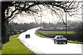
A37 at Clutton
The sun had just come out after a short sharp rainstorm. The reflections on the wet road made this tricky to photograph (taking pictures like this makes you realise just how sophisticated the human eye is!), but I like the result.
Image: © John Winder
Taken: 8 Jan 2015
0.02 miles
2
2009 : The A37 at Clutton
Or, more accurately, at the western edge of Clutton. Heading north to Pensford and Bristol.
Image: © Maurice Pullin
Taken: 13 Feb 2009
0.06 miles
3
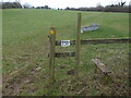
Dog flap
A curious sign on a stile of sorts - or at least it would be if it was not next to an open space where a gate was. It is assumed that it is not an instruction.
Image: © Neil Owen
Taken: 11 Feb 2021
0.08 miles
4
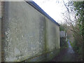
A wall that has many visitors
The narrow and dark lane that bounds the north of Clutton runs past a wall that has some noticeably soft rendering. Quite how many 'visitors' have left their mark is difficult to tally but the wall is almost completely covered with scratchings.
Image: © Neil Owen
Taken: 15 Jan 2021
0.10 miles
5
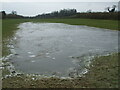
It'll take a blade
This overnight flooding has been turned into a frozen patch that is quite deep in places.
Image: © Neil Owen
Taken: 11 Feb 2021
0.10 miles
6
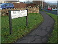
Rogers Close
Does he keep his enemies closer?
Image: © Neil Owen
Taken: 15 Jan 2021
0.13 miles
7
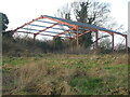
An airy barn
This structure has been like this for many years now. Will it ever be finished?
Image: © Neil Owen
Taken: 15 Jan 2021
0.14 miles
8
2009 : Rogers Close, Clutton
A residential side road off the A37 with a pleasant view of Clutton Hill.
Image: © Maurice Pullin
Taken: 13 Feb 2009
0.15 miles
9
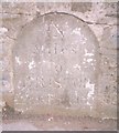
Old Milestone by the A37, Upper Bristol Road, Clutton
Carved stone post by the A37, in parish of CLUTTON (BATH AND NORTH EAST SOMERSET District), Clutton opposite Warwick Arms, embedded in stone wall, on East side of road. Bristol stone - Roman, erected by the Bristol turnpike trust in the 18th century.
Inscription reads:-
IX
Miles
To
BRISTOL
from Bridge
Milestone Society National ID: SO_BRCT09.
Image: © JR Dowding
Taken: 4 Nov 2002
0.17 miles
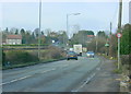
10
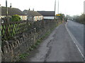
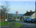
The Upper Bristol Road in Clutton
The busy A37, opposite the old Warick Arms pub of late, has a milestone in the wall. See Image] for a closer look.
Image: © Neil Owen
Taken: 15 Jan 2021
0.17 miles