IMAGES TAKEN NEAR TO
Clutton Hill, BRISTOL, BS39 5QJ
Introduction
This page details the photographs taken nearby to Clutton Hill, BS39 5QJ by members of the Geograph project.
The Geograph project started in 2005 with the aim of publishing, organising and preserving representative images for every square kilometre of Great Britain, Ireland and the Isle of Man.

There are currently over 7.5m images from over14,400 individuals and you can help contribute to the project by visiting https://www.geograph.org.uk
Image Map (Loading...)


Getting Data...Please wait
Leaflet Map data © OpenStreetMap
Images are licensed for reuse under creativecommons.org/licenses/by-sa/2.0
Notes
- Clicking on the map will re-center to the selected point.
- The higher the marker number, the further away the image location is from the centre of the postcode.
Image Listing (21 Images Found)
Images are licensed for reuse under creativecommons.org/licenses/by-sa/2.0
Image
Details
Distance
1
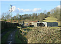
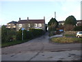
2010 : Brickyard Farm
At the foot of Blackberry Hill.
Image: © Maurice Pullin
Taken: 1 Mar 2010
0.03 miles
2
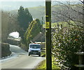
2009 : A bit more of Clutton Hill
Clutton Hill appears on the map to be a fairly insignificant hamlet, a quick search of the www will soon dispel that idea but I will let you have that pleasure for yourself.
Image: © Maurice Pullin
Taken: 13 Feb 2009
0.15 miles
3
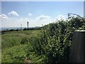
Blackberry Hill Trig Pillar Flush Bracket S2556
Image: © thejackrustles
Taken: 23 Jun 2021
0.18 miles
4
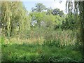
On the map it features as a large and prominent pond
In reality this damp spot adjacent to the Hunter's Rest car park is marked only by a concentration of bulrushes and a circle of willow trees.
Image: © Dr Duncan Pepper
Taken: 10 Sep 2014
0.19 miles
5
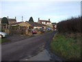
2009 : Clutton Hill from the top
Clutton village is about a mile away.
Image: © Maurice Pullin
Taken: 13 Feb 2009
0.19 miles
8
Ordnance Survey Cut Mark
This OS cut mark can be found on the front of the Hunters Rest. It marks a point 175.259m above mean sea level.
Image: © Adrian Dust
Taken: 15 Sep 2016
0.21 miles
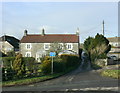
9

The Hunters Rest Inn
Tucked away along a quiet country lane and far from larger settlements, the pub has been here for well over a century. In fact it dates from around 1750, built as a hunting lodge for The Earl of Warwick. When the later Earl sold off much of his lands in 1892, this inn welcomed the many miners who were brought to the area when the Somerset collieries were working.
The inn has a benchmark on the wall near the white drainpipe - see Image
Image: © Neil Owen
Taken: 15 Jan 2021
0.21 miles
10

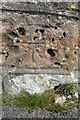
Pockmarked benchmark on the inn
The corner stone of the Hunters Rest Inn was selected in the twentieth century for an Ordnance Survey benchmark. Over the course of time the inn expanded so this is no longer at the corner; the stone has also suffered some degradation.
See https://www.bench-marks.org.uk/bm78863 for the entry in the Benchmark Database and Image] for a wider view.
Image: © Neil Owen
Taken: 15 Jan 2021
0.21 miles