IMAGES TAKEN NEAR TO
Maynard Terrace, BRISTOL, BS39 5EQ
Introduction
This page details the photographs taken nearby to Maynard Terrace, BS39 5EQ by members of the Geograph project.
The Geograph project started in 2005 with the aim of publishing, organising and preserving representative images for every square kilometre of Great Britain, Ireland and the Isle of Man.

There are currently over 7.5m images from over14,400 individuals and you can help contribute to the project by visiting https://www.geograph.org.uk
Image Map (Loading...)


Getting Data...Please wait
Leaflet Map data © OpenStreetMap
Images are licensed for reuse under creativecommons.org/licenses/by-sa/2.0
Notes
- Clicking on the map will re-center to the selected point.
- The higher the marker number, the further away the image location is from the centre of the postcode.
Image Listing (4 Images Found)
Images are licensed for reuse under creativecommons.org/licenses/by-sa/2.0
Image
Details
Distance
1
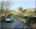
2009 : At the bottom of Clutton Hill
About to leave the village near its eastern extremity.
Image: © Maurice Pullin
Taken: 13 Feb 2009
0.09 miles
2
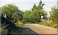
Site of Clutton station
View NW off Station Road, in general direction of Bristol: ex-GW Bristol - Radstock - Frome line, closed 2/11/59 to passengers, 10/6/63 to goods.
Image: © Ben Brooksbank
Taken: 5 May 1987
0.15 miles
3
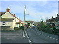
2009 : Station Road, Clutton
The station and the line have long been closed.
-------------------------------------------------
Coal has been worked in North Somerset and the Bristol region for many centuries, and was possibly even being mined in the region during Roman times.
Locally, mining was being carried out in Pensford and Stratton-on-the-Fosse by the end of the 17th century. In 1763 a deep coal seam was discovered in Radstock, and soon many other shafts were sunk in the surrounding villages. Pits in Radstock and Clandown had reached depths of over 1000 feet by the early 19th century.
Demand for coal was at its peak during the early decades of the 20th century, but gradually demand fell for coal and the mines in the region closed one by one.
Clutton had three pits in the vicinity – Burchells (sometimes spelt Burchills or Birchill's) Fry’s Bottom, and Greyfield. They belonged to the Earl of Warwick’s estate, which owned all the land in the parish of Clutton.
The above was copied from: http://www.clutton.org.uk/index.html?/history.html which has much more of interest, I commend you to it.
Image: © Maurice Pullin
Taken: 13 Feb 2009
0.21 miles
4
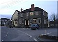
The Railway Hotel, Clutton
Alas, the railway line is long gone!
Image: © Roger Cornfoot
Taken: 12 Mar 2007
0.23 miles