IMAGES TAKEN NEAR TO
Birchwood Lane, BRISTOL, BS39 4NG
Introduction
This page details the photographs taken nearby to Birchwood Lane, BS39 4NG by members of the Geograph project.
The Geograph project started in 2005 with the aim of publishing, organising and preserving representative images for every square kilometre of Great Britain, Ireland and the Isle of Man.

There are currently over 7.5m images from over14,400 individuals and you can help contribute to the project by visiting https://www.geograph.org.uk
Image Map
Images are licensed for reuse under creativecommons.org/licenses/by-sa/2.0
Notes
- Clicking on the map will re-center to the selected point.
- The higher the marker number, the further away the image location is from the centre of the postcode.
Image Listing (28 Images Found)
Images are licensed for reuse under creativecommons.org/licenses/by-sa/2.0
Image
Details
Distance
1
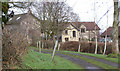
Birchwood House
It has this lovely drive/bridleway which goes down to the ruins of Woollard Tannery.
Image: © Rick Crowley
Taken: 14 Jan 2009
0.01 miles
2
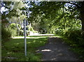
Birchwood Lane
This part of the lane changes from a more ancient style track into part tarmac surfacing. Birchwood House is just up the way and is the last home along the length. Perhaps in this way the evolution can be seen as it goes from a footway to a modern road.
Image: © Neil Owen
Taken: 25 Jul 2017
0.01 miles
3
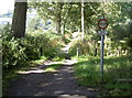
Birchwood Lane
Looking northwards, the vehicular access is reduced by the bollards and the fact there is no more tarmac. What was a modern roadway becomes a rougher track. Three foot three keeps most motors out.
Image: © Neil Owen
Taken: 25 Jul 2017
0.02 miles

5

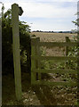
Birchwood Lane Byway
This BOAT has a 1 metre width restriction TRO along it's entire length.
Image: © James Ayres
Taken: 10 Jul 2011
0.05 miles
6
To Publow
A footpath across what appears to be a barley field goes towards the village of Publow.
Image: © Neil Owen
Taken: 25 Jul 2017
0.06 miles
7
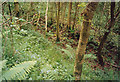
Lord's Wood: dry leat course
This leat provided water for a vanished eighteenth-century wire mill and it is interesting to see the associated pond has been restored in recent years - Image Enlarge the Geograph map and you will see that on leaving the wood the leat once ran out on embankment to work an overshot waterwheel. The tannery was on the other side of the Candlestick Brook and had a shorter leat, further down the slope. See also Image] and Image]
Image: © Martin Bodman
Taken: Unknown
0.13 miles
8
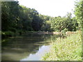
The old mill pond, reclaimed
Bumping into a local man, he explained that the landowner had this old mill pond cleared a few years ago. Once it would have provided a reliable water supply for the mills and tannery lower down in Wollard, but became disused and Nature subsequently filled it with vegetation. There must have been a lot of effort in removing the overgrowth to return this delightful feature.
Image: © Neil Owen
Taken: 25 Jul 2017
0.14 miles
9
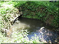
Old stone bridge and embankment on Candlestick Brook
Image: © James Ayres
Taken: 10 Jul 2011
0.15 miles
10
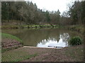
Mill pond in Lord's Wood
The man-made pond, with a semi-concrete spillway.
Image: © Neil Owen
Taken: 5 Mar 2021
0.16 miles