IMAGES TAKEN NEAR TO
Mill Lane, BRISTOL, BS39 4HX
Introduction
This page details the photographs taken nearby to Mill Lane, BS39 4HX by members of the Geograph project.
The Geograph project started in 2005 with the aim of publishing, organising and preserving representative images for every square kilometre of Great Britain, Ireland and the Isle of Man.

There are currently over 7.5m images from over14,400 individuals and you can help contribute to the project by visiting https://www.geograph.org.uk
Image Map
Images are licensed for reuse under creativecommons.org/licenses/by-sa/2.0
Notes
- Clicking on the map will re-center to the selected point.
- The higher the marker number, the further away the image location is from the centre of the postcode.
Image Listing (65 Images Found)
Images are licensed for reuse under creativecommons.org/licenses/by-sa/2.0
Image
Details
Distance
1
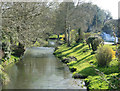
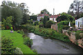
2010 : River Chew looking upstream at Woollard
Another look at this attractive river.
The Chew rises on the northern slopes of the Mendip Hills at Chewton Mendip, flows south to Chew Magna via Litton and the Chew Valley Lake then east through Pensford and Woollard.
Acker Bilk was born in Pensford and this scene reminds me of his song "That's My Home" though the shady elm trees have long been lost to the Dutch elm disease.
Thanks to Rick Crowley for pointing out the error.
Image: © Maurice Pullin
Taken: 9 Apr 2010
0.01 miles
2
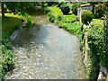
River Chew, Woollard
Innocuous-looking at the moment, this river flooded in a major way on 10 July 1968 and took down the bridge that used to cross the river. The bridge has since been replaced.
Image: © Brian Robert Marshall
Taken: 1 Jul 2007
0.02 miles
3
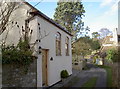
The old chapel in Mill Lane
This modest building along the banks of the River Chew has an interesting history. Originally believed to be a farm building, it was appointed as a Baptist chapel in the nineteenth century. It also appears to have served as a farmworkers' refuge before changing in the 1970s. Then it was a store and a catering concern, which caused a certain amount of village disdain over parking. Eventually it closed and was left unoccupied. Now it appears that the extensive renovation carried out will not allow it to become a commercial property, although it is offered as a private residence.
Image: © Neil Owen
Taken: 2 Feb 2016
0.03 miles
4
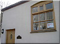
For sale or rent
This tiny building is currently on offer as a B1 class office, be it on contract or purchase. It used to be a chapel. See Image] for a wider view.
Image: © Neil Owen
Taken: 2 Feb 2016
0.03 miles
6
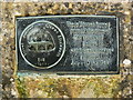
Close-up of the memorial to the flood, Woollard
The memorial is adjacent to the River Chew which flooded in a big way on 10 July 1968. The stones used to create the memorial came from the bridge of the time which was destroyed by the flood.
Image: © Brian Robert Marshall
Taken: 1 Jul 2007
0.04 miles
7
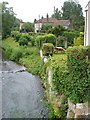
The Chew at Woollard
A similar view to Image, taken a couple of years later; a little shed has emerged from creepers. In the background, the C18 Woollard House is listed http://www.imagesofengland.org.uk/Details/Default.aspx?id=32634&mode=adv . Looking upstream.
Image: © Derek Harper
Taken: 3 Jun 2005
0.04 miles
8
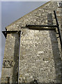
Chew Cottage
This interesting building, right by the bridge in Woollard, was originally a bridge chapel. The exterior retains a decorative ashlar cill band of shields within trefoils.
Image: © Neil Owen
Taken: 2 Feb 2016
0.05 miles
9
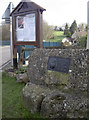
Notice the old stones
Woollard notice board beside a flagpole and the remnants of the old bridge lost in the floods of 1968. The green metal railings are on the modern replacement bridge.
Image: © Neil Owen
Taken: 2 Feb 2016
0.05 miles
10
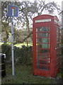
You can't phone for an ambulance
But if you are having a heart attack, the AED kit will be what you need. Another village phone box has found a different use...
Image: © Neil Owen
Taken: 2 Feb 2016
0.05 miles