IMAGES TAKEN NEAR TO
Wick Lane, BRISTOL, BS39 4BT
Introduction
This page details the photographs taken nearby to Wick Lane, BS39 4BT by members of the Geograph project.
The Geograph project started in 2005 with the aim of publishing, organising and preserving representative images for every square kilometre of Great Britain, Ireland and the Isle of Man.

There are currently over 7.5m images from over14,400 individuals and you can help contribute to the project by visiting https://www.geograph.org.uk
Image Map (Loading...)


Getting Data...Please wait
Leaflet Map data © OpenStreetMap
Images are licensed for reuse under creativecommons.org/licenses/by-sa/2.0
Notes
- Clicking on the map will re-center to the selected point.
- The higher the marker number, the further away the image location is from the centre of the postcode.
Image Listing (11 Images Found)
Images are licensed for reuse under creativecommons.org/licenses/by-sa/2.0
Image
Details
Distance
1

2010 : East of south from Wick Lane
View from a bridge which once spanned the South Somerset Railway.
Salter's Brook flows through the valley to the left, joining the River Chew in Pensford about half a mile downstream.
The hamlet on the hill to the left is Whitley Batts.
Image: © Maurice Pullin
Taken: 5 Jul 2010
0.06 miles
2

2010 : West from Wick Lane
The corner of a disused farm building and an equally disused forecourt.
Upper Stanton Drew hides under the hill almost at our feet but Stanton Drew itself appears a little further over. You can see the parish church in the original.
The hills in the distance are on the other side of Chew Magna.
Image: © Maurice Pullin
Taken: 5 Jul 2010
0.08 miles
3

2010 : North of east from Wick Lane
Looking across the valley of Salter's Brook. A substantial fence protects the drop into the valley.
Stantonbury Hill is in the distance to the left covered in trees with Winsbury Hill to the right of it.
Image: © Maurice Pullin
Taken: 5 Jul 2010
0.11 miles
4
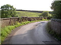
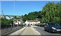
Whittley Batts bridge
A small but sharp bend in the road as it traverses the old railway line below. See Image] for the view towards the village.
Image: © Neil Owen
Taken: 28 Jul 2011
0.12 miles
5

2010 : North east from Wick Lane
A field apparently used for exercising horses, then a view of part of Pensford.
Lansdown near Bath is on the horizon.
Image: © Maurice Pullin
Taken: 5 Jul 2010
0.12 miles
6
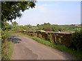
Wick Lane over the railway
A small but sharp bend in the road as it traverses the old railway line below. See Image] for the view in the opposite direction.
Image: © Neil Owen
Taken: 28 Jul 2011
0.12 miles
7
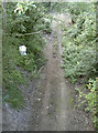
The old line below
Since the Beeching closures and then the awful flood of 1968, the railway line through Pensford has been lifted.
Image: © Neil Owen
Taken: 28 Jul 2011
0.13 miles
8
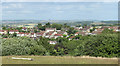
2010 : East from Wick Lane, Pensford
Housing south of Pensford is on the other side of the valley.
On the skyline left of centre a clump of trees marks Kelston Round Hill Image
Image: © Maurice Pullin
Taken: 5 Jul 2010
0.14 miles
10
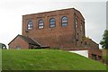
Converted mine building
Called 'Winding Engine House' this building's one end of old industrial buildings in the old Somerset coalfield close to Pensford village.
Image: © Peter Goodwin
Taken: 16 Jun 2007
0.21 miles