IMAGES TAKEN NEAR TO
High Street, BRISTOL, BS39 4BQ
Introduction
This page details the photographs taken nearby to High Street, BS39 4BQ by members of the Geograph project.
The Geograph project started in 2005 with the aim of publishing, organising and preserving representative images for every square kilometre of Great Britain, Ireland and the Isle of Man.

There are currently over 7.5m images from over14,400 individuals and you can help contribute to the project by visiting https://www.geograph.org.uk
Image Map (Loading...)


Getting Data...Please wait
Leaflet Map data © OpenStreetMap
Images are licensed for reuse under creativecommons.org/licenses/by-sa/2.0
Notes
- Clicking on the map will re-center to the selected point.
- The higher the marker number, the further away the image location is from the centre of the postcode.
Image Listing (105 Images Found)
Images are licensed for reuse under creativecommons.org/licenses/by-sa/2.0
Image
Details
Distance
1
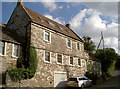
The Old Schoolhouse
The village made a living from local coal mining during the previous two centuries, so it became prudent to provide some form of education.
Image: © Neil Owen
Taken: 3 Oct 2016
0.02 miles
2
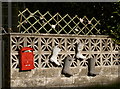
Welly wall
Some unusual garden features in Pensford.
Image: © Neil Owen
Taken: 3 Oct 2016
0.03 miles
3

2010 : A37 New Road, Pensford
Heading south toward Clutton and Farrington Gurney.
Image: © Maurice Pullin
Taken: 5 Jul 2010
0.04 miles
4
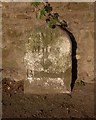
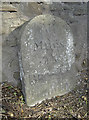
Pensford marker stone
A roadside stone seems to bear the legend 'A+T'. It does not appear to be a boundary stone as it is in the middle of the High Street, so perhaps it refers to property? Surely it's not a memorial.
Image: © Neil Owen
Taken: 3 Oct 2016
0.04 miles
5
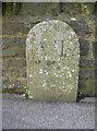
Old Milestone, A37, New Road, Pensford
The milestone is set in the pavement against a stone wall on the east side of the road. Parish of Publow (Bath and North East Somerset District). Carved stone post, Bristol stone - Roman design, erected by the Bristol turnpike trust in the 18th century.
Inscription reads:-
VI
Miles
To
BRISTOL
Iron Bridge
Milestone Society National ID: SO_BRCT06
Image: © Mike Faherty
Taken: Unknown
0.04 miles
6
New Road milestone
This milestone may well be partly buried under modern tarmac, but old maps record it as being six miles to Bristol but also fifteen to Wells - which it does not here. Also, it is interesting to see that it refers to the bridge, a short distance away from its position.
Image: © Neil Owen
Taken: 3 Oct 2016
0.04 miles
7
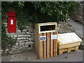
A new bin on the High Street
Along with the post box and grit bin, a new litter bin has been provided. Supplied by the local council, it affords some extra revenue by an advertising sign.
Image: © Neil Owen
Taken: 5 Mar 2021
0.05 miles
8
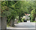
2010 : Down the hill into Pensford
Along High Street. This really was Pensford's main road in former days.
Image: © Maurice Pullin
Taken: 16 Aug 2010
0.05 miles
9
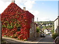
The Old Bakery
This Grade II listed house was originally a bakery, but the mass of red creeper makes a case for itself.
Image: © Neil Owen
Taken: 3 Oct 2016
0.06 miles
10
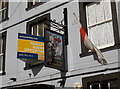
Fantastic business opportunity
For dragon-slaying knights, perhaps?
Image: © Neil Owen
Taken: 3 Oct 2016
0.06 miles