IMAGES TAKEN NEAR TO
Dyers Lane, BRISTOL, BS37 9XT
Introduction
This page details the photographs taken nearby to Dyers Lane, BS37 9XT by members of the Geograph project.
The Geograph project started in 2005 with the aim of publishing, organising and preserving representative images for every square kilometre of Great Britain, Ireland and the Isle of Man.

There are currently over 7.5m images from over14,400 individuals and you can help contribute to the project by visiting https://www.geograph.org.uk
Image Map
Images are licensed for reuse under creativecommons.org/licenses/by-sa/2.0
Notes
- Clicking on the map will re-center to the selected point.
- The higher the marker number, the further away the image location is from the centre of the postcode.
Image Listing (15 Images Found)
Images are licensed for reuse under creativecommons.org/licenses/by-sa/2.0
Image
Details
Distance
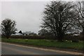
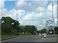
2
Oaklands Business park
looking East to the entrance, situated in the south of the square.
Image: © Chris Shaw
Taken: Unknown
0.08 miles
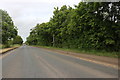
5
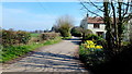
Dyers Lane
Adjacent to Bradfield Farl on the right, ahead.
Image: © Jonathan Billinger
Taken: 23 Mar 2012
0.10 miles
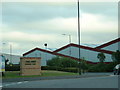
7
The western end of Iron Acton Way
Where Iron Acton Way begins, south of Engine Common on the outskirts of Yate.
Image: © Ruth Riddle
Taken: 15 Jun 2012
0.11 miles

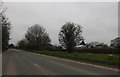
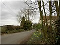
9
Stone Stile, Iron Acton
Off Dyers Lane, on Gloucestershire footpath LIA/18/30 looking NW from the road.
The footpath passes through a horse training field.
Image: © Gillian Otlet
Taken: 20 Jun 2023
0.15 miles
10

VW Campers at Danbury Motorcaravaners
A colourful row of the iconic VW Campers
Image: © Eirian Evans
Taken: 26 Nov 2009
0.16 miles