IMAGES TAKEN NEAR TO
Wotton Road, BRISTOL, BS37 9XQ
Introduction
This page details the photographs taken nearby to Wotton Road, BS37 9XQ by members of the Geograph project.
The Geograph project started in 2005 with the aim of publishing, organising and preserving representative images for every square kilometre of Great Britain, Ireland and the Isle of Man.

There are currently over 7.5m images from over14,400 individuals and you can help contribute to the project by visiting https://www.geograph.org.uk
Image Map
Images are licensed for reuse under creativecommons.org/licenses/by-sa/2.0
Notes
- Clicking on the map will re-center to the selected point.
- The higher the marker number, the further away the image location is from the centre of the postcode.
Image Listing (10 Images Found)
Images are licensed for reuse under creativecommons.org/licenses/by-sa/2.0
Image
Details
Distance
1
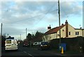
Semi-detached houses
A pair of semi-detached houses on the Wotton Road south of Rangeworthy.
Image: © Ruth Riddle
Taken: 14 Jan 2012
0.05 miles
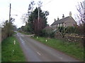
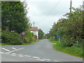
2
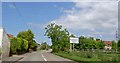
Entering Rangeworthy on the Wotton Road
Image: © Steve Fareham
Taken: 4 Jun 2008
0.12 miles
3
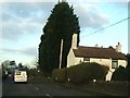
Cottage beside Wotton Road
This white cottage beside Wotton Road is dwarfed by the trees just north of it.
Image: © Ruth Riddle
Taken: 14 Jan 2012
0.16 miles
4
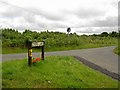
Dyers Lane
Junction with Chaingate Lane.
Image: © Steve Fareham
Taken: 15 Jul 2008
0.18 miles
5
Patch Elm Lane
Eponymous farm is just along on the right after the cottages.
Image: © Jonathan Billinger
Taken: 30 Mar 2007
0.18 miles
6
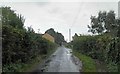
A wet Chaingate Lane near Engine Common
Image: © Steve Fareham
Taken: 27 Sep 2012
0.19 miles
7
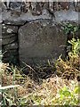
Old Milestone by B4058, Wotton Road, just North of Chaingate Lane junction,
The Milestone is located inset into field wall, opposite bus shelter and footpath on the West of the road. Parish of Iron Acton (South Gloucestershire District). Carved stone post, Wotton stone design, erected by the Wotton under Edge (Division) turnpike trust in the 19th Century.
Inscription reads:- XI / / BRISTOL
Milestone Society National ID: GL_WERY09
Image: © Roadside Relics
Taken: 6 Jul 2023
0.22 miles
8
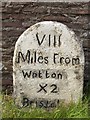
Milestone on B4058 Wotton Road
8 miles from Wotton-Under-Edge + unorthodox Roman numerals for 12 to Bristol or 2 x 8 = 16 (my mileometer says somewhere in between!)?
Image: © Lyn Haigh
Taken: 11 Sep 2008
0.23 miles
9
Chaingate Lane
Looking north-east from the B4058; a large tractor is approaching the camera position.
Image: © Jonathan Billinger
Taken: 24 Sep 2010
0.23 miles
10
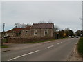
Rangeworthy, former chapel
Ebenezer Chapel, built 1874; now converted for residential use.
Image: © Mike Faherty
Taken: 11 Apr 2010
0.25 miles