IMAGES TAKEN NEAR TO
Latteridge Road, BRISTOL, BS37 9TN
Introduction
This page details the photographs taken nearby to Latteridge Road, BS37 9TN by members of the Geograph project.
The Geograph project started in 2005 with the aim of publishing, organising and preserving representative images for every square kilometre of Great Britain, Ireland and the Isle of Man.

There are currently over 7.5m images from over14,400 individuals and you can help contribute to the project by visiting https://www.geograph.org.uk
Image Map
Images are licensed for reuse under creativecommons.org/licenses/by-sa/2.0
Notes
- Clicking on the map will re-center to the selected point.
- The higher the marker number, the further away the image location is from the centre of the postcode.
Image Listing (7 Images Found)
Images are licensed for reuse under creativecommons.org/licenses/by-sa/2.0
Image
Details
Distance
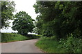
1
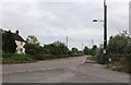
The B4059 at the end of Latteridge Lane
Image: © David Howard
Taken: 23 May 2020
0.09 miles
2
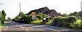
Mirrors on the roadside.
Aids for vehicles exiting onto the road.
Image: © Steve Fareham
Taken: 10 Sep 2007
0.11 miles
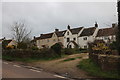
5
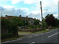
Latteridge
Cottages at Lateridge village near centre of grid square
Image: © Chris Shaw
Taken: Unknown
0.19 miles
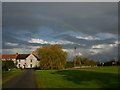
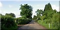
7
Latteridge Lane at the junction of Lark's Lane
Lark's Lane leads to a large electricity substation on the left.
Image: © David Howard
Taken: 23 May 2020
0.23 miles