IMAGES TAKEN NEAR TO
Northmead Lane, BRISTOL, BS37 9AA
Introduction
This page details the photographs taken nearby to Northmead Lane, BS37 9AA by members of the Geograph project.
The Geograph project started in 2005 with the aim of publishing, organising and preserving representative images for every square kilometre of Great Britain, Ireland and the Isle of Man.

There are currently over 7.5m images from over14,400 individuals and you can help contribute to the project by visiting https://www.geograph.org.uk
Image Map (Loading...)


Getting Data...Please wait
Leaflet Map data © OpenStreetMap
Images are licensed for reuse under creativecommons.org/licenses/by-sa/2.0
Notes
- Clicking on the map will re-center to the selected point.
- The higher the marker number, the further away the image location is from the centre of the postcode.
Image Listing (11 Images Found)
Images are licensed for reuse under creativecommons.org/licenses/by-sa/2.0
Image
Details
Distance
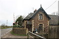
1
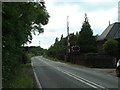
Acton Crossing & Cottage
Looking west near centre of square
Image: © Chris Shaw
Taken: Unknown
0.09 miles
3
Goods line in Iron Acton
This is now only used by the quarry which closed in 2013 and reopened in 2017 https://en.wikipedia.org/wiki/Thornbury_branch_line
Image: © David Howard
Taken: 14 Mar 2020
0.14 miles
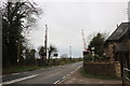
4
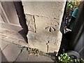
Ordnance Survey Cut Mark
This OS cut mark can be found on the house north side of the road. It marks a point 50.914m above mean sea level.
Image: © Adrian Dust
Taken: 6 Oct 2022
0.15 miles
5
Crossing Cottage, ex-Iron Acton Station
The adjacent station closed in 1944 and demolished some time since. https://en.wikipedia.org/wiki/Iron_Acton_railway_station
Image: © David Howard
Taken: 14 Mar 2020
0.16 miles
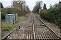
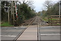
6
Level crossing on Latteridge Road, Iron Acton
This is still used for occasional quarry trains from Thornbury
Image: © David Howard
Taken: 14 Mar 2020
0.16 miles
8
Goods line in Iron Acton
Crossing the B4059. This is now only used by the quarry which closed in 2013 and reopened in 2017 https://en.wikipedia.org/wiki/Thornbury_branch_line
Image: © David Howard
Taken: 14 Mar 2020
0.20 miles
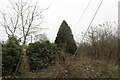
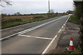
9
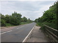
The B4059 road from Rudgeway to Iron Acton
Taken from Ladden bows bridge.
Image: © Dr Duncan Pepper
Taken: 10 Jun 2013
0.24 miles
10
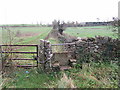
An old-style old stile
Old stone stiles of this type are quite rare in South Gloucestershire.
Image: © Ruth Riddle
Taken: 10 Dec 2011
0.25 miles