IMAGES TAKEN NEAR TO
Westerleigh Road, BRISTOL, BS37 8RF
Introduction
This page details the photographs taken nearby to Westerleigh Road, BS37 8RF by members of the Geograph project.
The Geograph project started in 2005 with the aim of publishing, organising and preserving representative images for every square kilometre of Great Britain, Ireland and the Isle of Man.

There are currently over 7.5m images from over14,400 individuals and you can help contribute to the project by visiting https://www.geograph.org.uk
Image Map
Images are licensed for reuse under creativecommons.org/licenses/by-sa/2.0
Notes
- Clicking on the map will re-center to the selected point.
- The higher the marker number, the further away the image location is from the centre of the postcode.
Image Listing (7 Images Found)
Images are licensed for reuse under creativecommons.org/licenses/by-sa/2.0
Image
Details
Distance
1
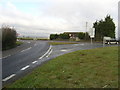
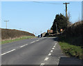
B4465 Westerleigh Hill Junction, South Gloucestershire
A rather complicated junction, where the B4465 road turns right from here, but appears to go right to left. The road up the hill from Westerleigh doesn't quite meet as a crossroads at this point, and now there are two short slip roads too!
Image: © ChurchCrawler
Taken: 27 Dec 2005
0.06 miles
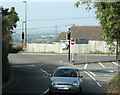
3
2009 : B4465 Westerleigh Road looking south
At the top of Westerleigh Hill.
The B4465 turns right at Pucklechurch and meets the East Bristol ringroad near Shortwood.
Image: © Maurice Pullin
Taken: 19 Sep 2009
0.08 miles
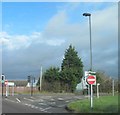
4
2009 : Crossroads with traffic lights
Taken about 4 years after Image Either the traffic lights have been put in since, or Mr. ChurchCrawler had them removed specially for his image.
Westerleigh is at the bottom of the hill beyond. Further over much of the farmland around Yate and Chipping Sodbury has been taken for housing estates.
The B4465 takes a turn to the right here.
Image: © Maurice Pullin
Taken: 19 Sep 2009
0.08 miles
5
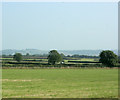
2009 : East from Westerleigh Road
At the top of Westerleigh Hill.
The Cotswold escarpment in the distance is but two miles over, but the hazy conditions of the day make it look much further away.
Image: © Maurice Pullin
Taken: 19 Sep 2009
0.14 miles
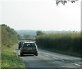
6
2011 : Minor road heading east near Westerleigh
Up Westerleigh Hill, Westerleigh Hill Farm is in sight.
Part of a good route east out of Bristol if you are fed up with mad motorways and awful A roads.
Codrington is just under 2 miles along then on to Tormarton.
Image: © Maurice Pullin
Taken: 20 Mar 2011
0.17 miles
7
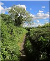
Byway from the B4465
Restricted byway LWE 47/10 leaves the B road southwards along this modest pathway.
Image: © Derek Harper
Taken: 29 May 2015
0.18 miles