IMAGES TAKEN NEAR TO
North Road, BRISTOL, BS37 7LW
Introduction
This page details the photographs taken nearby to North Road, BS37 7LW by members of the Geograph project.
The Geograph project started in 2005 with the aim of publishing, organising and preserving representative images for every square kilometre of Great Britain, Ireland and the Isle of Man.

There are currently over 7.5m images from over14,400 individuals and you can help contribute to the project by visiting https://www.geograph.org.uk
Image Map
Images are licensed for reuse under creativecommons.org/licenses/by-sa/2.0
Notes
- Clicking on the map will re-center to the selected point.
- The higher the marker number, the further away the image location is from the centre of the postcode.
Image Listing (4 Images Found)
Images are licensed for reuse under creativecommons.org/licenses/by-sa/2.0
Image
Details
Distance
1
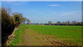
Footpath along the field edge
The first ten metres or so are in the gridsquare.
Image: © Jonathan Billinger
Taken: 23 Mar 2012
0.16 miles
2
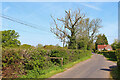
Engine Common Lane
House on Engine Common Lane. The footpath entrance is by the fence.
Image: © Wayland Smith
Taken: 30 Apr 2022
0.19 miles
3
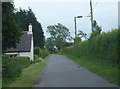
Engine Common Lane
Looking south down one of a series of roughly parallel roads north of Yate.
Image: © Ruth Riddle
Taken: 15 Jun 2012
0.19 miles
4
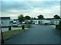
Engine Common Caravan Park
East of the lane towards the NE corner of the square
Image: © Chris Shaw
Taken: Unknown
0.24 miles