IMAGES TAKEN NEAR TO
Brookfield Close, BRISTOL, BS37 6PP
Introduction
This page details the photographs taken nearby to Brookfield Close, BS37 6PP by members of the Geograph project.
The Geograph project started in 2005 with the aim of publishing, organising and preserving representative images for every square kilometre of Great Britain, Ireland and the Isle of Man.

There are currently over 7.5m images from over14,400 individuals and you can help contribute to the project by visiting https://www.geograph.org.uk
Image Map
Images are licensed for reuse under creativecommons.org/licenses/by-sa/2.0
Notes
- Clicking on the map will re-center to the selected point.
- The higher the marker number, the further away the image location is from the centre of the postcode.
Image Listing (20 Images Found)
Images are licensed for reuse under creativecommons.org/licenses/by-sa/2.0
Image
Details
Distance
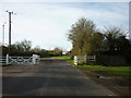
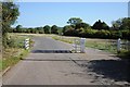
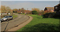
2
Cattle grid, Sodbury Common
A reverse view of Image, on a much gloomier day. The unfenced road beyond forks.
Image: © Derek Harper
Taken: 27 Sep 2014
0.08 miles
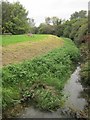
3
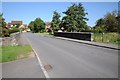
Bridge on Hatters Lane, Yate
Bridge carrying Hatters Lane over the River Frome in Yate.
Image: © Philip Halling
Taken: 26 Sep 2015
0.10 miles
4
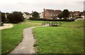
Path to Chipping Sodbury
Crossing the footbridge shown from the other side in Image], this is footpath LSO/10, and the central houses are in Caroline Close, in Image
Image: © Derek Harper
Taken: 27 Sep 2014
0.12 miles
5

Footbridge, Chipping Sodbury
A winding footpath, LSO/10, crosses a tiny stream near its source to reach St Johns Way.
Image: © Derek Harper
Taken: 27 Sep 2014
0.12 miles
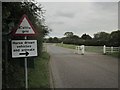
6
Cattle grid on Horton Road
Horton Road enters unfenced common land here, hence the cattle grid.
Image: © Philip Halling
Taken: 26 Sep 2015
0.12 miles
7
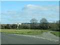
Road junction on Sodbury Common
The junction where Portway Lane leaves Horton Road.
Image: © Ruth Riddle
Taken: 25 Feb 2012
0.13 miles
8
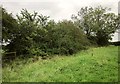
Hedge near Trinity Lane
Footpath LSO/10 goes through this satisfactorily unkempt hedge on the left.
Image: © Derek Harper
Taken: 27 Sep 2014
0.14 miles
9
River Frome
From the Monarch's Way as it crosses a footbridge, looking downstream.
Image: © Derek Harper
Taken: 27 Sep 2014
0.14 miles
10
Hatters Lane, Chipping Sodbury
Curving away from the town centre to cross the River Frome where the parapets are and where it also crosses the Frome Valley Walkway.
Image: © Derek Harper
Taken: 6 Mar 2020
0.14 miles