IMAGES TAKEN NEAR TO
Badminton Road, BRISTOL, BS37 5JE
Introduction
This page details the photographs taken nearby to Badminton Road, BS37 5JE by members of the Geograph project.
The Geograph project started in 2005 with the aim of publishing, organising and preserving representative images for every square kilometre of Great Britain, Ireland and the Isle of Man.

There are currently over 7.5m images from over14,400 individuals and you can help contribute to the project by visiting https://www.geograph.org.uk
Image Map
Images are licensed for reuse under creativecommons.org/licenses/by-sa/2.0
Notes
- Clicking on the map will re-center to the selected point.
- The higher the marker number, the further away the image location is from the centre of the postcode.
Image Listing (58 Images Found)
Images are licensed for reuse under creativecommons.org/licenses/by-sa/2.0
Image
Details
Distance
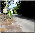
1
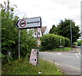
Weight restriction sign on a Nibley corner, South Gloucestershire
Facing the A432 Badminton Road on the corner of Nibley Lane.
No vehicles heavier than 7.5 tonnes on Nibley Lane towards Westerleigh, except for access.
A depiction of a hand on a pink sign points along Nibley Lane towards Shabby Chic. http://www.geograph.org.uk/photo/5471908
Image: © Jaggery
Taken: 20 Jul 2017
0.01 miles
2
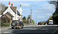
2012 : A432 Badminton Road passing The Swan at Nibley
Heading east to Yate and Chipping Sodbury.
At first sight the Swan appears to be closed, sign missing, faded boards, but fear not, blackboards outside the door give the clue and their website is definitely active http://www.theswanatnibley.co.uk/index.html and the board is probably away for re-painting.
Image: © Maurice Pullin
Taken: 2 Apr 2012
0.01 miles
3
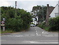
SSE along Nibley Lane, Nibley, South Gloucestershire
Viewed across the A432 Badminton Road, from the edge of the Swan Inn. http://www.geograph.org.uk/photo/5460521
No vehicles heavier than 7.5 tonnes ahead, except for access. Nibley Lane leads to Westerleigh.
Image: © Jaggery
Taken: 12 Jul 2017
0.01 miles
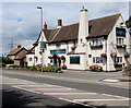
4
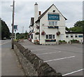
The Swan Inn, Nibley, South Gloucestershire
The Swan is on the north side of the A432 Badminton Road, opposite the Nibley Lane junction. http://www.geograph.org.uk/photo/5460530
http://www.geograph.org.uk/photo/5460523 to the name sign.
Image: © Jaggery
Taken: 12 Jul 2017
0.02 miles
5
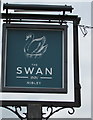
Swan Inn name sign, Nibley, South Gloucestershire
Located here. http://www.geograph.org.uk/photo/5460521
Image: © Jaggery
Taken: 12 Jul 2017
0.02 miles
6
Swan Inn, Nibley, South Gloucestershire
The Swan is on the north side of the A432 Badminton Road, opposite the Nibley Lane junction.
http://www.geograph.org.uk/photo/5460523 to the name sign.
Image: © Jaggery
Taken: 20 Jul 2017
0.02 miles
7
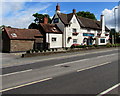
The Swan Inn, Nibley, South Gloucestershire
The Swan is on the north side of the A432 Badminton Road, opposite the Nibley Lane junction.
http://www.geograph.org.uk/photo/5460523 to the name sign.
Image: © Jaggery
Taken: 20 Jul 2017
0.02 miles
8
A432 directions sign facing Nibley Lane, Nibley, South Gloucestershire
Faded in July 2017, the sign shows turn left at the A432 Badminton Road junction for Bristol or right for Yate.
Image: © Jaggery
Taken: 20 Jul 2017
0.03 miles
9
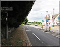
Eastern boundary of Nibley, South Gloucestershire
The A432 Badminton Road from Yate reaches Nibley. The Swan http://www.geograph.org.uk/photo/5472351 is on the right.
Image: © Jaggery
Taken: 20 Jul 2017
0.04 miles
10

Inconspicuous Nibley boundary sign, South Gloucestershire
The small sign on the left faces westbound traffic on the A432 Badminton Road from Yate.
Image: © Jaggery
Taken: 12 Jul 2017
0.04 miles