IMAGES TAKEN NEAR TO
The Hollows, BRISTOL, BS36 2UX
Introduction
This page details the photographs taken nearby to The Hollows, BS36 2UX by members of the Geograph project.
The Geograph project started in 2005 with the aim of publishing, organising and preserving representative images for every square kilometre of Great Britain, Ireland and the Isle of Man.

There are currently over 7.5m images from over14,400 individuals and you can help contribute to the project by visiting https://www.geograph.org.uk
Image Map (Loading...)


Getting Data...Please wait
Leaflet Map data © OpenStreetMap
Images are licensed for reuse under creativecommons.org/licenses/by-sa/2.0
Notes
- Clicking on the map will re-center to the selected point.
- The higher the marker number, the further away the image location is from the centre of the postcode.
Image Listing (23 Images Found)
Images are licensed for reuse under creativecommons.org/licenses/by-sa/2.0
Image
Details
Distance
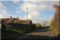
1
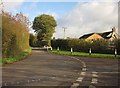
Junction, Coalsack Lane
The priority seems to have changed in the last few years. The house is Meadow Lodge Farm.
Image: © Derek Harper
Taken: 22 Nov 2013
0.02 miles
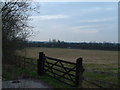
2
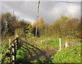
Gate by Meadow Lodge Farm
At the junction of Coalsack Lane with The Hollows.
Image: © Derek Harper
Taken: 22 Nov 2013
0.04 miles
3
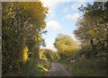
The Hollows
The lane from Coalsack Lane to Henfield passes between trees.
Image: © Derek Harper
Taken: 22 Nov 2013
0.05 miles
4
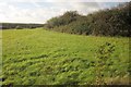
Field by Coalsack Lane
The view from the gate shown in Image
Image: © Derek Harper
Taken: 22 Nov 2013
0.06 miles
5
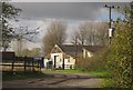
American Spas
Premises of a spa installation firm, on The Hollows, the lane shown in Image
Image: © Derek Harper
Taken: 22 Nov 2013
0.14 miles
6
Farmland near the M4 motorway
Looking South from Coalsack Lane
Image: © John Phillips
Taken: 23 Mar 2006
0.14 miles
7
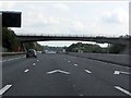
M4 Motorway - minor road overbridge near Weston Farm
Image: © J Whatley
Taken: 22 Sep 2010
0.14 miles
8
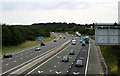
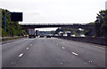
2011 : M4 looking west from the Westerleigh Road overbridge
Toward the junction with the M32.
The echelons are painted on the road to help photographers line up their shots, motorists hardly notice them. Geographers are especially grateful.
Image: © Maurice Pullin
Taken: 20 Jun 2011
0.15 miles
9
Coalsack Farm
On Coalsack Lane. The farmhouse is C17 and described at http://list.english-heritage.org.uk/resultsingle.aspx?uid=1215565&searchtype=mapsearch .
Image: © Derek Harper
Taken: 22 Nov 2013
0.15 miles