IMAGES TAKEN NEAR TO
Box Hedge Lane, BRISTOL, BS36 2UW
Introduction
This page details the photographs taken nearby to Box Hedge Lane, BS36 2UW by members of the Geograph project.
The Geograph project started in 2005 with the aim of publishing, organising and preserving representative images for every square kilometre of Great Britain, Ireland and the Isle of Man.

There are currently over 7.5m images from over14,400 individuals and you can help contribute to the project by visiting https://www.geograph.org.uk
Image Map (Loading...)


Getting Data...Please wait
Leaflet Map data © OpenStreetMap
Images are licensed for reuse under creativecommons.org/licenses/by-sa/2.0
Notes
- Clicking on the map will re-center to the selected point.
- The higher the marker number, the further away the image location is from the centre of the postcode.
Image Listing (2 Images Found)
Images are licensed for reuse under creativecommons.org/licenses/by-sa/2.0
Image
Details
Distance
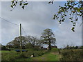
2
2011 : South west from Ram Hill
The view is in the direction of Pucklechurch, a little left of centre though there is little to be seen of it. Also not easily seen, partly hidden by the smaller tree left of centre is Freezing Hill Image which can be seen in the larger version.
Image: © Maurice Pullin
Taken: 20 Mar 2011
0.23 miles