IMAGES TAKEN NEAR TO
Henfield Road, BRISTOL, BS36 2TE
Introduction
This page details the photographs taken nearby to Henfield Road, BS36 2TE by members of the Geograph project.
The Geograph project started in 2005 with the aim of publishing, organising and preserving representative images for every square kilometre of Great Britain, Ireland and the Isle of Man.

There are currently over 7.5m images from over14,400 individuals and you can help contribute to the project by visiting https://www.geograph.org.uk
Image Map
Images are licensed for reuse under creativecommons.org/licenses/by-sa/2.0
Notes
- Clicking on the map will re-center to the selected point.
- The higher the marker number, the further away the image location is from the centre of the postcode.
Image Listing (55 Images Found)
Images are licensed for reuse under creativecommons.org/licenses/by-sa/2.0
Image
Details
Distance
3
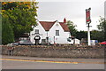
Ring O' Bells, Coalpit Heath, Gloucestershire 2021
Image: © Ray Bird
Taken: 15 Oct 2021
0.06 miles
4
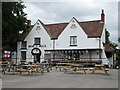
Ring o' Bells, Coalpit Heath
The old pub used to stand in a fairly rural area until the new road, houses and the school were built nearby in the twentieth century.
Image: © Neil Owen
Taken: 9 Jul 2021
0.07 miles
5
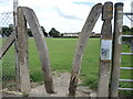
A concrete and wooden stile
And metal, too. A mixture of materials.
Image: © Neil Owen
Taken: 9 Jul 2021
0.09 miles
6
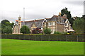
Manor Hall, Coalpit Heath, Gloucestershire 2021
Image: © Ray Bird
Taken: 15 Oct 2021
0.10 miles
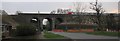
7
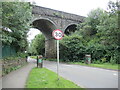
Henfield Road railway bridge
The Great Western Railway came this way in the late 1800s, spanning the gap between Winterbourne and Ram Hill. The old road, carried underneath, is now dedicated as a Quiet Lane.
Image: © Neil Owen
Taken: 9 Jul 2021
0.10 miles
8
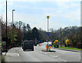
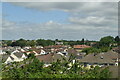
2012 : A432 Badminton Road at Coalpit Heath
A location much improved in appearance since its inception as a mining village in the South Gloucestershire coalfield.
After Coalpit Heath the A432 heads south west to Downend and Bristol.
Image: © Maurice Pullin
Taken: 2 Apr 2012
0.11 miles
9
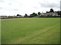
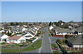
The Recreation Ground, Badminton Road
A large playing field, associated with the school buildings (to the right) of earlier years.
Image: © Neil Owen
Taken: 9 Jul 2021
0.11 miles
10
Not the Church
I cannot believe that in March 07 I found a square with no geograph in it that also had a church. So... not falling for the trap I photographed something else.
The train has just left Bristol Parkway 4 km to the east and is heading towards London. The bridge may not be as big as the viaduct just down the line Image but is interesting none the less.
I leave the church for someone else.
Image: © Graham Richards
Taken: 25 Mar 2007
0.12 miles