IMAGES TAKEN NEAR TO
Badminton Road, BRISTOL, BS36 2QJ
Introduction
This page details the photographs taken nearby to Badminton Road, BS36 2QJ by members of the Geograph project.
The Geograph project started in 2005 with the aim of publishing, organising and preserving representative images for every square kilometre of Great Britain, Ireland and the Isle of Man.

There are currently over 7.5m images from over14,400 individuals and you can help contribute to the project by visiting https://www.geograph.org.uk
Image Map (6 Images)


Getting Data...Please wait
Leaflet Map data © OpenStreetMap
Images are licensed for reuse under creativecommons.org/licenses/by-sa/2.0
Notes
- Clicking on the map will re-center to the selected point.
- The higher the marker number, the further away the image location is from the centre of the postcode.
Image Listing (6 Images Found)
Images are licensed for reuse under creativecommons.org/licenses/by-sa/2.0
Image
Details
Distance
4
Heathcote Drive, Badminton Road, Coalpit Heath
Image: © Dr Duncan Pepper
Taken: 2 Jul 2013
0.17 miles
5
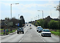
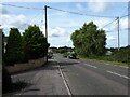
2012 : A432 Badminton Road at Coalpit Heath
The South Gloucestershire Coalfield was closed around 1950 but Coalpit Heath still has a Miners Social Club http://cphvh.webs.com/silverlining.htm
Image: © Maurice Pullin
Taken: 2 Apr 2012
0.23 miles
6
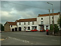
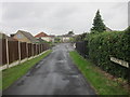
Frampton End
Looking south toward the shops opposite Frampton End lane.
Image: © Chris Shaw
Taken: Unknown
0.24 miles