IMAGES TAKEN NEAR TO
The Causeway, BRISTOL, BS36 2PE
Introduction
This page details the photographs taken nearby to The Causeway, BS36 2PE by members of the Geograph project.
The Geograph project started in 2005 with the aim of publishing, organising and preserving representative images for every square kilometre of Great Britain, Ireland and the Isle of Man.

There are currently over 7.5m images from over14,400 individuals and you can help contribute to the project by visiting https://www.geograph.org.uk
Image Map (Loading...)


Getting Data...Please wait
Leaflet Map data © OpenStreetMap
Images are licensed for reuse under creativecommons.org/licenses/by-sa/2.0
Notes
- Clicking on the map will re-center to the selected point.
- The higher the marker number, the further away the image location is from the centre of the postcode.
Image Listing (11 Images Found)
Images are licensed for reuse under creativecommons.org/licenses/by-sa/2.0
Image
Details
Distance
1
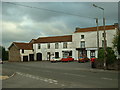
Frampton End
Looking south toward the shops opposite Frampton End lane.
Image: © Chris Shaw
Taken: Unknown
0.14 miles
2
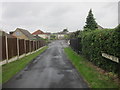
Heathcote Drive, Badminton Road, Coalpit Heath
Image: © Dr Duncan Pepper
Taken: 2 Jul 2013
0.15 miles
5
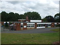
Junior school in Frampton Cotterell
This school dates from the late 1960s and takes in the older pupils in the primary school system. The younger ones are taught at the Brockeridge site a short walk away. Both will shortly be educated in the brand new school being built opposite this one.
Image: © Neil Owen
Taken: 27 Jul 2019
0.18 miles
6
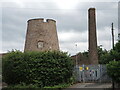
Frampton's industrial skyline
The tower of a late 18th/early 19th century windmill stands close to a chimney. The tower is now a residential property, which is Grade II listed and remains one of the best examples left in Britain.
Image: © Neil Owen
Taken: 9 Jul 2021
0.21 miles
7
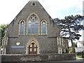
Zion Chapel, Frampton Cotterell
The area was without a church for many years, so a group of interested people gathered to propose that one be built. There are records of visits by George Whitfield and one of the Wesley brothers in previous times that may have added weight to the plans. Land was secured and foundations laid in 1794, with the chapel opened a few months after, at a cost of £353/3/7 and one halfpenny. However, even with a few alterations it was outgrown and a new church was built in 1873 at a cost of £1557/15/7d.
A benchmark was made in the early twentieth century on the left of shot - see Image
Image: © Neil Owen
Taken: 9 Jul 2021
0.22 miles
8
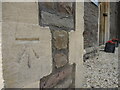
Benchmark on the Zion Chapel
A fine, twentieth century cutmark on the east of Zion Chapel. See https://www.bench-marks.org.uk/bm84758 for the entry in the Benchmark Database and Image] for a wider view.
Image: © Neil Owen
Taken: 9 Jul 2021
0.22 miles
9
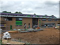
New school for Frampton
Work carries on at the site near Church Road. It is a controversial development of the schooling in the village as it will combine the former junior school (just opposite) with the infants' school a short walk south. The latter was the Brockeridge school, dating back into the nineteenth century and thought by some to be an historic asset. However, the old school was not approved for official listing and so the grounds were sold off to developers; new homes will be built on that. Now the two sections will be brought together in the new school here.
Image: © Neil Owen
Taken: 27 Jul 2019
0.22 miles
10
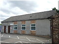
Frampton Cotterell scouts' hall
The 1st Frampton Cotterell scouts group HQ - a post-war building next to the chapel.
Image: © Neil Owen
Taken: 9 Jul 2021
0.23 miles