IMAGES TAKEN NEAR TO
Woodend Road, BRISTOL, BS36 2JF
Introduction
This page details the photographs taken nearby to Woodend Road, BS36 2JF by members of the Geograph project.
The Geograph project started in 2005 with the aim of publishing, organising and preserving representative images for every square kilometre of Great Britain, Ireland and the Isle of Man.

There are currently over 7.5m images from over14,400 individuals and you can help contribute to the project by visiting https://www.geograph.org.uk
Image Map (Loading...)


Getting Data...Please wait
Leaflet Map data © OpenStreetMap
Images are licensed for reuse under creativecommons.org/licenses/by-sa/2.0
Notes
- Clicking on the map will re-center to the selected point.
- The higher the marker number, the further away the image location is from the centre of the postcode.
Image Listing (17 Images Found)
Images are licensed for reuse under creativecommons.org/licenses/by-sa/2.0
Image
Details
Distance
1
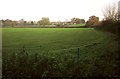
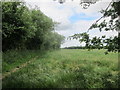
Field in the Frome valley
Seen from footpath LFC/34 near Harris Barton. The houses in the background are at Frampton Cotterell.
Image: © Derek Harper
Taken: 22 Nov 2013
0.14 miles
3
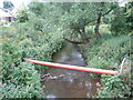
River Frome
From bridge at Frampton Cotterell - looking SW from the NE corner of the square.
Image: © Chris Shaw
Taken: Unknown
0.17 miles
4
The Live and Let Live is dying
This pub at the junction of Park Lane and Clyde Road is looking rather sorry for itself these days, and with a somewhat ironic name.
Incidentally, Park Lane was known as Penny Lane until the twentieth century.
Image: © Neil Owen
Taken: 9 Jul 2021
0.18 miles
5
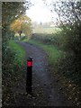
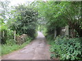
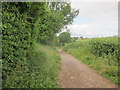
Footpath to Nightingale's Bridge
The path (footpath LFC/34) shown in Image, seen in autumn.
Image: © Derek Harper
Taken: 22 Nov 2013
0.19 miles
6
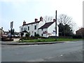
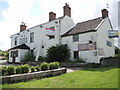
Live and Let Live
Public house in Frampton Cotterell
Image: © Eirian Evans
Taken: 7 Apr 2019
0.19 miles
7
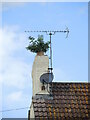
Converted to green fuels?
A chimney pot seems to be redundant. Better give it trim before the signal gets disturbed, though.
Image: © Neil Owen
Taken: 9 Jul 2021
0.20 miles
9
Footpath heading down to Nightingale's Bridge
Image: © Dr Duncan Pepper
Taken: 3 Jul 2013
0.21 miles
10

Farmland by the Frome
A gateway on the east side of Nightingale's Bridge - see Image] - with the river on the left. The distant houses are on Rectory Road, Frampton Cotterell. Footpath LFC/52X, used by the Frome Valley Walkway, goes through the kissing gate and along the edge of the field by the river. That's a blackbird flying off to the left.
Image: © Derek Harper
Taken: 22 Nov 2013
0.22 miles