IMAGES TAKEN NEAR TO
Park Lane, BRISTOL, BS36 2HA
Introduction
This page details the photographs taken nearby to Park Lane, BS36 2HA by members of the Geograph project.
The Geograph project started in 2005 with the aim of publishing, organising and preserving representative images for every square kilometre of Great Britain, Ireland and the Isle of Man.

There are currently over 7.5m images from over14,400 individuals and you can help contribute to the project by visiting https://www.geograph.org.uk
Image Map
Images are licensed for reuse under creativecommons.org/licenses/by-sa/2.0
Notes
- Clicking on the map will re-center to the selected point.
- The higher the marker number, the further away the image location is from the centre of the postcode.
Image Listing (17 Images Found)
Images are licensed for reuse under creativecommons.org/licenses/by-sa/2.0
Image
Details
Distance
1
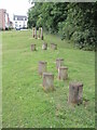
Fitness equipment on the new housing estate
All provisions for a healthy community near Green Crescent.
Image: © Neil Owen
Taken: 9 Jul 2021
0.08 miles
2
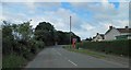
Park Lane (Frampton Cotterell) phone box
Image: © Steve Fareham
Taken: 7 Jul 2011
0.10 miles
3
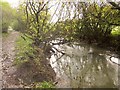
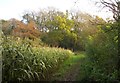
River Frome at Rockwell Wood
Looking downstream, with the Frome Valley Walkway on the left.
Image: © Derek Harper
Taken: 22 Nov 2013
0.10 miles
4
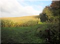
Maize by the Frome Valley Walkway
On the right is Rockwell Wood. In the foreground is some sort of hay rake.
Image: © Derek Harper
Taken: 22 Nov 2013
0.11 miles
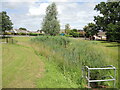
5
Frome Valley Walkway
The path follows footpath LFC/51X down the left bank of the river, which is just behind the bushes on the right. Ahead on the river cliff is Rockwell Wood.
Image: © Derek Harper
Taken: 22 Nov 2013
0.11 miles
6
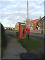
Old telephone box
This battered old telephone box contrasts with the brand new housing development on the other side of Park Lane.
Image: © Ruth Riddle
Taken: 14 Jan 2012
0.11 miles
7
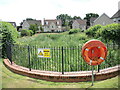
A pond in a suburban street
The very new housing development has brought with it some interesting water features, requiring safety equipment, although there does not appear to have been any water on what was previously farmland.
Image: © Neil Owen
Taken: 9 Jul 2021
0.13 miles
8
A marshy pond by Wylington Road
This area has been very recently developed; the plans included this stretch of marshy pond.
Image: © Neil Owen
Taken: 9 Jul 2021
0.17 miles
9
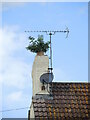
Converted to green fuels?
A chimney pot seems to be redundant. Better give it trim before the signal gets disturbed, though.
Image: © Neil Owen
Taken: 9 Jul 2021
0.18 miles
10
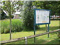
Notice board on Heather Avenue
Whilst the area has been massively developed of late, the parish notice board is still a feature.
Image: © Neil Owen
Taken: 9 Jul 2021
0.18 miles