IMAGES TAKEN NEAR TO
Clyde Road, BRISTOL, BS36 2EA
Introduction
This page details the photographs taken nearby to Clyde Road, BS36 2EA by members of the Geograph project.
The Geograph project started in 2005 with the aim of publishing, organising and preserving representative images for every square kilometre of Great Britain, Ireland and the Isle of Man.

There are currently over 7.5m images from over14,400 individuals and you can help contribute to the project by visiting https://www.geograph.org.uk
Image Map (Loading...)


Getting Data...Please wait
Leaflet Map data © OpenStreetMap
Images are licensed for reuse under creativecommons.org/licenses/by-sa/2.0
Notes
- Clicking on the map will re-center to the selected point.
- The higher the marker number, the further away the image location is from the centre of the postcode.
Image Listing (15 Images Found)
Images are licensed for reuse under creativecommons.org/licenses/by-sa/2.0
Image
Details
Distance
1
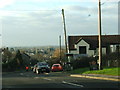
Telephone box on Church Road
This telephone box is located on Church Road at the northern edge of Frampton Cotterell, almost opposite the turning to Ryecroft Road.
Image: © Ruth Riddle
Taken: 14 Jan 2012
0.05 miles
2
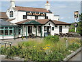
Rising in Frampton
The Rising Sun has been serving pints in Frampton Cotterell for decades.
Image: © Neil Owen
Taken: 9 Jul 2021
0.09 miles
3
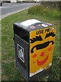
Use me - but use me properly!
This highly decorated waste bin also carries a notice: it warns people not to use it for their domestic waste or threatens to remove the bin!
Image: © Neil Owen
Taken: 27 Jul 2019
0.15 miles
4
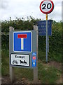
Frampton End Road
The road is blocked by a closable barrier further up, but is still open to cycles and horse-drawn vehicles.
Image: © Neil Owen
Taken: 27 Jul 2019
0.15 miles
5
Truly Scrumptious
Café in Frampton End.
Image: © Steve Fareham
Taken: 6 Mar 2008
0.15 miles
6
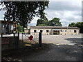
Frampton Cotterell Royal British Legion
A single storey building, looking not unlike a typical barracks. The building dates from post-war.
Image: © Neil Owen
Taken: 9 Jul 2021
0.16 miles
7
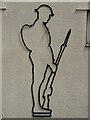
An outline with a poppy
Frampton Cotterell's legion building features an outline soldier, finished off with a poppy.
Image: © Neil Owen
Taken: 9 Jul 2021
0.16 miles
9
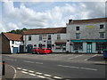
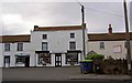
Shops on Church Road
A collection of small businesses gathered around the main road.
Image: © Neil Owen
Taken: 27 Jul 2019
0.16 miles
10
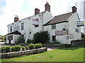
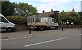
The Live and Let Live is dying
This pub at the junction of Park Lane and Clyde Road is looking rather sorry for itself these days, and with a somewhat ironic name.
Incidentally, Park Lane was known as Penny Lane until the twentieth century.
Image: © Neil Owen
Taken: 9 Jul 2021
0.17 miles