IMAGES TAKEN NEAR TO
Walnut Close, BRISTOL, BS36 2DL
Introduction
This page details the photographs taken nearby to Walnut Close, BS36 2DL by members of the Geograph project.
The Geograph project started in 2005 with the aim of publishing, organising and preserving representative images for every square kilometre of Great Britain, Ireland and the Isle of Man.

There are currently over 7.5m images from over14,400 individuals and you can help contribute to the project by visiting https://www.geograph.org.uk
Image Map (Loading...)


Getting Data...Please wait
Leaflet Map data © OpenStreetMap
Images are licensed for reuse under creativecommons.org/licenses/by-sa/2.0
Notes
- Clicking on the map will re-center to the selected point.
- The higher the marker number, the further away the image location is from the centre of the postcode.
Image Listing (51 Images Found)
Images are licensed for reuse under creativecommons.org/licenses/by-sa/2.0
Image
Details
Distance
1
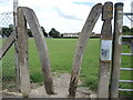
A concrete and wooden stile
And metal, too. A mixture of materials.
Image: © Neil Owen
Taken: 9 Jul 2021
0.01 miles
2
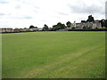
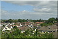
The Recreation Ground, Badminton Road
A large playing field, associated with the school buildings (to the right) of earlier years.
Image: © Neil Owen
Taken: 9 Jul 2021
0.03 miles
3

Tributes by the recreation ground
Close by is the Badminton Road crossroads - a place where accidents have happened too often.
Image: © Neil Owen
Taken: 9 Jul 2021
0.05 miles
4

Manor Hall, Coalpit Heath, Gloucestershire 2021
Image: © Ray Bird
Taken: 15 Oct 2021
0.05 miles
5
Badminton Road, Coalpit Heath, Gloucestershire 2021
Image: © Ray Bird
Taken: 15 Oct 2021
0.05 miles
6
Ring O' Bells, Coalpit Heath, Gloucestershire 2021
Image: © Ray Bird
Taken: 15 Oct 2021
0.05 miles
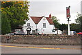
7
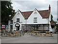
Ring o' Bells, Coalpit Heath
The old pub used to stand in a fairly rural area until the new road, houses and the school were built nearby in the twentieth century.
Image: © Neil Owen
Taken: 9 Jul 2021
0.06 miles
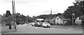
9
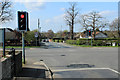
2012 : Traffic lights on the A432 at Coalpit Heath
Seen from Roundways, Beesmoor Road is straight ahead going to Frampton Cotterell, the A432 Badminton Road crosses.
Coalpit Heath and Frampton Cotterell are already pretty well joined up, Winterbourne is only just detached, Downend and Mangotsfield are only a few fields away to the south. When these are hauled in they will all be part of Bristol. Yate and Chipping Sodbury, look out!
Image: © Maurice Pullin
Taken: 2 Apr 2012
0.08 miles
10

Old Headstones, St Saviour's Churchyard, Coalpit Heath, Gloucestershire 2021
Image: © Ray Bird
Taken: 15 Oct 2021
0.08 miles