IMAGES TAKEN NEAR TO
Meadow Mead, BRISTOL, BS36 2BQ
Introduction
This page details the photographs taken nearby to Meadow Mead, BS36 2BQ by members of the Geograph project.
The Geograph project started in 2005 with the aim of publishing, organising and preserving representative images for every square kilometre of Great Britain, Ireland and the Isle of Man.

There are currently over 7.5m images from over14,400 individuals and you can help contribute to the project by visiting https://www.geograph.org.uk
Image Map (Loading...)


Getting Data...Please wait
Leaflet Map data © OpenStreetMap
Images are licensed for reuse under creativecommons.org/licenses/by-sa/2.0
Notes
- Clicking on the map will re-center to the selected point.
- The higher the marker number, the further away the image location is from the centre of the postcode.
Image Listing (32 Images Found)
Images are licensed for reuse under creativecommons.org/licenses/by-sa/2.0
Image
Details
Distance
1
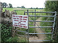
This is farm land, food for our cows
A firm but polite notice at the start of the footpath.
Image: © Neil Owen
Taken: 9 Jul 2021
0.07 miles
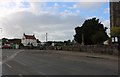
2
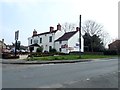
Live and Let Live
Public house in Frampton Cotterell
Image: © Eirian Evans
Taken: 7 Apr 2019
0.07 miles
3
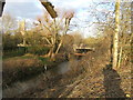
Iron drainage
A drain in Frampton Cotterell, close to the River Frome, showing its origins.
Gloucestershire had plenty of mining, coal and transport links in its past so iron foundries were common. One such was established in Howler's Slade near Tewkesbury. Owned by Trotter, Thomas and Co. it was sold to Richard Young of Berry Hill and Thomas Herbert in 1893. Here the Cannop foundry produced many cast iron utility products until Herbert's death in 1942. His son Ewart Thomas moved the works to the old Cinderford gas works site in 1957; the company closed in 1990.
Image: © Neil Owen
Taken: 9 Jul 2021
0.08 miles
4
The Live and Let Live is dying
This pub at the junction of Park Lane and Clyde Road is looking rather sorry for itself these days, and with a somewhat ironic name.
Incidentally, Park Lane was known as Penny Lane until the twentieth century.
Image: © Neil Owen
Taken: 9 Jul 2021
0.08 miles
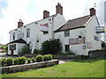
5
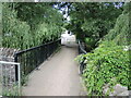
Parsonage Bridge over the River Frome
Rectory Road crosses the river here but is pedestrian only. In previous years the bridge was a bigger version and the road was known as Rectory Lane.
Image: © Neil Owen
Taken: 9 Jul 2021
0.08 miles
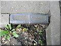
6
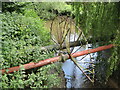
Pipe on Parsonage Bridge
Various connections over the River Frome, protected by fanned railings.
Image: © Neil Owen
Taken: 9 Jul 2021
0.08 miles
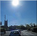
8
Church Bridge
Church Bridge over the River Frome in Frampton Cotterell is about 100 metres south of the parish church.
Image: © Ruth Riddle
Taken: 14 Jan 2012
0.13 miles
10
Roadworks on Church Road Frampton Cotterell
Image: © Steve Fareham
Taken: 21 May 2014
0.15 miles