IMAGES TAKEN NEAR TO
Crossley Close, BRISTOL, BS36 1PR
Introduction
This page details the photographs taken nearby to Crossley Close, BS36 1PR by members of the Geograph project.
The Geograph project started in 2005 with the aim of publishing, organising and preserving representative images for every square kilometre of Great Britain, Ireland and the Isle of Man.

There are currently over 7.5m images from over14,400 individuals and you can help contribute to the project by visiting https://www.geograph.org.uk
Image Map
Images are licensed for reuse under creativecommons.org/licenses/by-sa/2.0
Notes
- Clicking on the map will re-center to the selected point.
- The higher the marker number, the further away the image location is from the centre of the postcode.
Image Listing (2 Images Found)
Images are licensed for reuse under creativecommons.org/licenses/by-sa/2.0
Image
Details
Distance
1
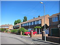
Bourne Close, Winterbourne
A classic post war late 1950's housing estate, in this case, a cul-de-sac. Probably cost around £1000 when new.
Image: © Dr Duncan Pepper
Taken: 4 Jun 2013
0.16 miles
2

Former chapel, Watley's End
Formerly an Ebenezer Chapel of the United Free Methodists, and surrounded by a cemetery, this is on Watley's End Road. It was built in 1868 "when the Methodist Community in the village split. It was built on twenty perches of land belonging to Henry & George Vaughan, the largest hat manufacturers in Watley’s End" http://www.southglos.gov.uk/Documents/Watley's%20End%20VDS%20-%20Final%20version%20-%203%20june%202013.pdf . Now a storage warehouse, according to that site.
Image: © Derek Harper
Taken: 22 Nov 2013
0.24 miles