IMAGES TAKEN NEAR TO
Ludwell Close, BRISTOL, BS36 1HG
Introduction
This page details the photographs taken nearby to Ludwell Close, BS36 1HG by members of the Geograph project.
The Geograph project started in 2005 with the aim of publishing, organising and preserving representative images for every square kilometre of Great Britain, Ireland and the Isle of Man.

There are currently over 7.5m images from over14,400 individuals and you can help contribute to the project by visiting https://www.geograph.org.uk
Image Map
Images are licensed for reuse under creativecommons.org/licenses/by-sa/2.0
Notes
- Clicking on the map will re-center to the selected point.
- The higher the marker number, the further away the image location is from the centre of the postcode.
Image Listing (12 Images Found)
Images are licensed for reuse under creativecommons.org/licenses/by-sa/2.0
Image
Details
Distance
1
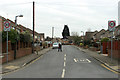
2012 : Bradley Avenue, Winterbourne
Seen from Flaxpits Lane.
Image: © Maurice Pullin
Taken: 16 Feb 2012
0.08 miles
2
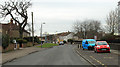
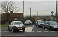
2012 : Flaxpits Lane, Winterbourne looking west
The vehicles are in a layby outside Winterbourne library.
Image: © Maurice Pullin
Taken: 16 Feb 2012
0.10 miles
3
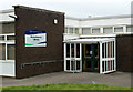
2012 : Winterbourne Library, Flaxpits Lane
No mention of threatened closure in their website http://www.southglos.gov.uk/NR/exeres/14cac893-cde1-4c65-90f7-a6cc8ed0baf6 - interesting.
Image: © Maurice Pullin
Taken: 16 Feb 2012
0.12 miles
4
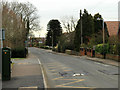
2012 : Flaxpits Lane, Winterbourne
Looking east.
Image: © Maurice Pullin
Taken: 16 Feb 2012
0.13 miles
5
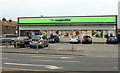
2012 : The Cooperative, Winterbourne
On the corner of Dragon Road and Flaxpits Lane, more parking on Flaxpits Lane and at the rear.
Nothing to be found on the web.
Image: © Maurice Pullin
Taken: 16 Feb 2012
0.14 miles
6
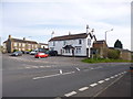
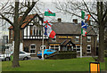
Winterbourne, George & Dragon
Pub at the corner of Winterbourne Hill and High Street. L-shaped bar, with three drinking areas. Pool, darts, TV and garden. Cask ales on offer at my visit: Wickwar Rover's, GWB Exhibitionist.
Image: © Mike Faherty
Taken: 29 Mar 2014
0.15 miles
7
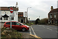
2012 : B4058 at the top of Winterbourne Hill
Heading south toward Hambrook, Frenchay and Bristol.
The George and Dragon is on the corner, mentioned in a number of websites, none of them have much to say.
Image: © Maurice Pullin
Taken: 16 Feb 2012
0.15 miles
8
2012 : The Royal Raj, High Street, Winterbourne
Indian cuisine as the name implies. Reviews in various websites including http://www.eatout.co.uk/restaurants/overview/royal-raj are generally good.
Image: © Maurice Pullin
Taken: 16 Feb 2012
0.17 miles
9
2012 : B4057 Beacon Lane at Winterbourne
The eastern end of the link road between Winterbourne and Patchway.
Image: © Maurice Pullin
Taken: 16 Feb 2012
0.18 miles
10
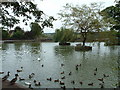
Flaxpits - The village pond at Winterbourne
View looking east over ducks expecting handouts
Image: © John Phillips
Taken: 28 Sep 2005
0.21 miles