IMAGES TAKEN NEAR TO
Coalsack Lane, BRISTOL, BS36 1AX
Introduction
This page details the photographs taken nearby to Coalsack Lane, BS36 1AX by members of the Geograph project.
The Geograph project started in 2005 with the aim of publishing, organising and preserving representative images for every square kilometre of Great Britain, Ireland and the Isle of Man.

There are currently over 7.5m images from over14,400 individuals and you can help contribute to the project by visiting https://www.geograph.org.uk
Image Map (Loading...)


Getting Data...Please wait
Leaflet Map data © OpenStreetMap
Images are licensed for reuse under creativecommons.org/licenses/by-sa/2.0
Notes
- Clicking on the map will re-center to the selected point.
- The higher the marker number, the further away the image location is from the centre of the postcode.
Image Listing (11 Images Found)
Images are licensed for reuse under creativecommons.org/licenses/by-sa/2.0
Image
Details
Distance
1
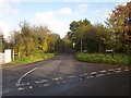
Ruffet Road
Seen across the T junction with Coalsack Lane. Beside the gatepost, a stile leads onto footpath LWE/33.
Image: © Derek Harper
Taken: 22 Nov 2013
0.04 miles
2
2011 : Coalsack Lane, Kendleshire
Heading east from the A432.
Coalsack Lane, a reminder of the coal mining industry which was once dominant in this area. Street names are the only things remaining on the surface.
Image: © Maurice Pullin
Taken: 20 Mar 2011
0.10 miles
3
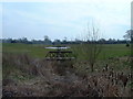
Kendleshire Golf Club
Water hazards here.
Image: © John Phillips
Taken: 23 Mar 2006
0.14 miles
4
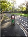
Coalsack Lane
Designated a quiet lane, with a speed limit of 30mph. “Quiet Lanes are
minor rural roads which are appropriate for shared use by walkers, cyclists, horse riders and motorised users. They should have low traffic flows travelling at low speeds.” http://assets.dft.gov.uk/publications/traffic-advisory-leaflets/quietlanes.pdf
Image: © Derek Harper
Taken: 22 Nov 2013
0.15 miles
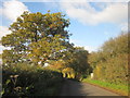
5
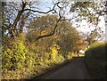
Coalsack Lane
Autumn tints on what is designated as a "quiet lane" with a speed limit of 30mph. Behind the hedge on the left is Kendleshire Golf Course. Image] looks in the opposite direction.
Image: © Derek Harper
Taken: 22 Nov 2013
0.16 miles
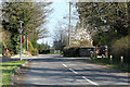
6
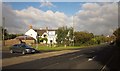
Kendleshire Crossroads
The A432 Badminton Road passes Down Road, the road to Winterbourne. Across the junction is Kendleshire Farm.
Image: © Derek Harper
Taken: 22 Nov 2013
0.17 miles
7
2011 : A432 Badminton Road at Kendleshire
Heading south east to Downend and Bristol.
Image: © Maurice Pullin
Taken: 20 Mar 2011
0.18 miles
8
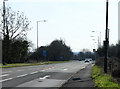
2011 : A432 at Kendleshire heading north west
Toward Coalpit Heath, Yate and Chipping Sodbury.
Near the middle of the South Gloucestershire coalfield though there is little to be seen on the surface.
The road to the left leads to Winterbourne Down and Winterbourne.
A winterbourne, old English, is a stream or brook which only flows during the winter months.
Image: © Maurice Pullin
Taken: 20 Mar 2011
0.19 miles
9
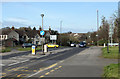
Coalsack Lane
This is a "quiet lane", hence the post on the right carrying the speed limit sign. See also Image], which looks in the other direction.
Image: © Derek Harper
Taken: 22 Nov 2013
0.20 miles
10
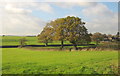
Trees near Kendleshire Farm
From Coalsack Lane, with oaks along field boundaries. The farm is on the right.
Image: © Derek Harper
Taken: 22 Nov 2013
0.21 miles