IMAGES TAKEN NEAR TO
Parson Street, BRISTOL, BS3 5PU
Introduction
This page details the photographs taken nearby to Parson Street, BS3 5PU by members of the Geograph project.
The Geograph project started in 2005 with the aim of publishing, organising and preserving representative images for every square kilometre of Great Britain, Ireland and the Isle of Man.

There are currently over 7.5m images from over14,400 individuals and you can help contribute to the project by visiting https://www.geograph.org.uk
Image Map
Images are licensed for reuse under creativecommons.org/licenses/by-sa/2.0
Notes
- Clicking on the map will re-center to the selected point.
- The higher the marker number, the further away the image location is from the centre of the postcode.
Image Listing (155 Images Found)
Images are licensed for reuse under creativecommons.org/licenses/by-sa/2.0
Image
Details
Distance
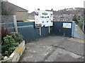
2
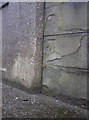
Benchmark on Parson Street station
A cutmark - listed on the Benchmark Database: http://www.bench-marks.org.uk/bm23479 - on the entrance to the railway station. See Image] for a wider view.
Image: © Neil Owen
Taken: 19 Dec 2011
0.04 miles
3
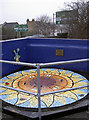
Mosaic in the station
A corner of the (open-air) entrance to Parson Street station has been illuminated by a piece of art, made by the nearby primary school and in collaboration with David Bowers of Mosaic Madness.
Image: © Neil Owen
Taken: 19 Dec 2011
0.04 miles
5
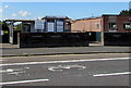
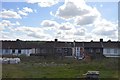
Entrance to Parson Street railway station, Bristol
From the A38 Parson Street. Managed by Great Western Railway, Parson Street (station code PSN) is a two-platform station between Bedminster station and Nailsea & Backwell station on the Bristol to Exeter Line.
Image: © Jaggery
Taken: 5 Sep 2018
0.04 miles
6
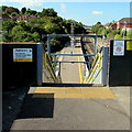
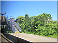
Platform 1 direction sign at Parson Street station, Bristol
At the top of the steps on the right here. https://www.geograph.org.uk/photo/5951952
Down the steps to platform 1 for trains to Weston-super-Mare and the West.
Image: © Jaggery
Taken: 5 Sep 2018
0.04 miles
7
Parson Street railway station mural, Bristol
On the A38 Parson Street perimeter wall of the footbridge https://www.geograph.org.uk/photo/5951952 above the eastern end of the station. The artwork is by pupils of Parson Street Primary School, funded by the Green Capital 2015, made possible by the Bridge Brigade, Severnside Community Partnership and Great Western Railway.
Image: © Jaggery
Taken: 5 Sep 2018
0.04 miles
8
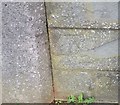
Ordnance Survey Cut Mark
This OS cut mark can be found on the SW parapet above Parson Street Station. It marks a point 25.539m above mean sea level.
Image: © Adrian Dust
Taken: 13 Mar 2020
0.04 miles
9
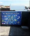
A small concourse above the platforms
Parson Street station is reached from the road entrance, spanning the tracks. An information board gives a little detail and flavour of its history, but a mosaic that used to be in the corner has now gone. See Image] for a reference.
Image: © Neil Owen
Taken: 17 Feb 2022
0.04 miles
10
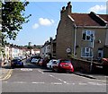
Hall Street, Bedminster, Bristol
Viewed across the A38 Parson Street. The 30mph speed limit drops to 20mph.
Image: © Jaggery
Taken: 5 Sep 2018
0.04 miles