IMAGES TAKEN NEAR TO
Avondown Court, Bedminster Road, BRISTOL, BS3 5NF
Introduction
This page details the photographs taken nearby to Avondown Court, Bedminster Road, BS3 5NF by members of the Geograph project.
The Geograph project started in 2005 with the aim of publishing, organising and preserving representative images for every square kilometre of Great Britain, Ireland and the Isle of Man.

There are currently over 7.5m images from over14,400 individuals and you can help contribute to the project by visiting https://www.geograph.org.uk
Image Map
Images are licensed for reuse under creativecommons.org/licenses/by-sa/2.0
Notes
- Clicking on the map will re-center to the selected point.
- The higher the marker number, the further away the image location is from the centre of the postcode.
Image Listing (118 Images Found)
Images are licensed for reuse under creativecommons.org/licenses/by-sa/2.0
Image
Details
Distance
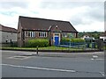
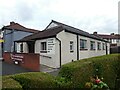
2
The library on Marksbury Road
Now sporting some solar panels as of last year.
Image: © Neil Owen
Taken: 17 Feb 2022
0.03 miles
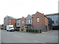
4
No more four star
This block of flats arrived only a few years ago and replaces an old Esso garage.
Image: © Neil Owen
Taken: 17 Feb 2022
0.06 miles
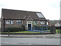
5

Ordnance Survey Cut Mark
This OS cut mark can be found on No181 Marksbury Road. It marks a point 11.180m above mean sea level.
Image: © Adrian Dust
Taken: 23 Aug 2022
0.06 miles
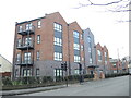
6
New flats on Bedminster Down Road
A large development of housing of over seventy flats, only a few years old.
Image: © Neil Owen
Taken: 17 Feb 2022
0.07 miles
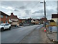
7
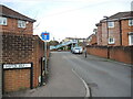
The top of Shepton Walk
The road is an interwar period development, but the continuation from here to the railway bridge is very much twenty-first century. The houses stand on what were several sets of sidings.
Image: © Neil Owen
Taken: 17 Feb 2022
0.08 miles
9
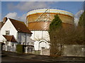
Gas holder
There were two such familiar 'gasometers', but one was bombed during WWII. The plant didn't explode, but the torrent of water released drowned nearby residents.
Image: © Neil Owen
Taken: 16 Jan 2009
0.09 miles
10
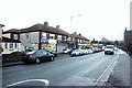
Shops in Bedminster Rd
This row of shops includes a barber and two convenience stores.
Image: © Nigel Mykura
Taken: 23 Dec 2021
0.09 miles