IMAGES TAKEN NEAR TO
Gorse Cover Road, BRISTOL, BS35 4NP
Introduction
This page details the photographs taken nearby to Gorse Cover Road, BS35 4NP by members of the Geograph project.
The Geograph project started in 2005 with the aim of publishing, organising and preserving representative images for every square kilometre of Great Britain, Ireland and the Isle of Man.

There are currently over 7.5m images from over14,400 individuals and you can help contribute to the project by visiting https://www.geograph.org.uk
Image Map (Loading...)


Getting Data...Please wait
Leaflet Map data © OpenStreetMap
Images are licensed for reuse under creativecommons.org/licenses/by-sa/2.0
Notes
- Clicking on the map will re-center to the selected point.
- The higher the marker number, the further away the image location is from the centre of the postcode.
Image Listing (158 Images Found)
Images are licensed for reuse under creativecommons.org/licenses/by-sa/2.0
Image
Details
Distance
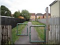
1
Path from Beach Avenue to Gorse Cover Road, Severn Beach
Pointing ahead, a public footpath sign is near the camera in Beach Avenue.
Image: © Jaggery
Taken: 13 Sep 2018
0.04 miles
2
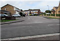
Gorse Cover Road houses, Severn Beach
This part of Gorse Cover Road is near Emmaus Church Centre on the right. https://www.geograph.org.uk/photo/5901529
Image: © Jaggery
Taken: 10 Sep 2018
0.05 miles
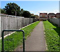
4
Footpath to Gorse Cover Road
Looking southeast from Beach Avenue.
Image: © Robin Stott
Taken: 16 Jul 2011
0.05 miles
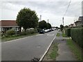
5
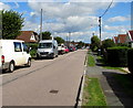
NE along Beach Avenue, Severn Beach
Looking to the northeast along the B4064 Beach Avenue. Ahead for New Passage, Redwick, Pilning.
Image: © Jaggery
Taken: 13 Sep 2018
0.06 miles
7
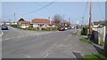
Bungalow on a Severn Beach corner
On the corner of Osborne Road (on the left) and Beach Avenue.
Originally, bungalow was used in English for a lightly-built house, with a veranda and one storey.
In current UK usage it is a convenient word for any one-storey dwelling.
Image: © Jaggery
Taken: 13 Sep 2018
0.07 miles
8
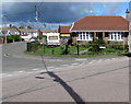
Emmaus Church Centre, Gorse Cover Road, Severn Beach
Emmaus Church Centre is a modern purpose-built building which opened in 1993. The history of the church dates from the 1930s when some Christians in Severn Beach met for worship and prayer in Nissen huts in Shaft Road.
https://www.geograph.org.uk/photo/5901581 to the information board on the right.
Image: © Jaggery
Taken: 10 Sep 2018
0.07 miles
9
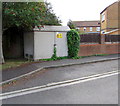
Gorse Cover Road electricity substation, Severn Beach
The identifier on the grey cabinet is 11/3710 SITE SEVERN BEACH.
Image: © Jaggery
Taken: 10 Sep 2018
0.07 miles
10
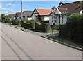
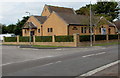
Bungalows and hedges, Beach Avenue, Severn Beach
Viewed across the B4064 Beach Avenue.
Image: © Jaggery
Taken: 13 Sep 2018
0.07 miles