IMAGES TAKEN NEAR TO
Gumhurn Lane, BRISTOL, BS35 4JL
Introduction
This page details the photographs taken nearby to Gumhurn Lane, BS35 4JL by members of the Geograph project.
The Geograph project started in 2005 with the aim of publishing, organising and preserving representative images for every square kilometre of Great Britain, Ireland and the Isle of Man.

There are currently over 7.5m images from over14,400 individuals and you can help contribute to the project by visiting https://www.geograph.org.uk
Image Map
Images are licensed for reuse under creativecommons.org/licenses/by-sa/2.0
Notes
- Clicking on the map will re-center to the selected point.
- The higher the marker number, the further away the image location is from the centre of the postcode.
Image Listing (14 Images Found)
Images are licensed for reuse under creativecommons.org/licenses/by-sa/2.0
Image
Details
Distance
1
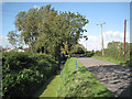
Deep ditch by Pilning Street
Part of a network of drainage channels that converge on Ellinghurst Rhine.
Roofs of Torrs Farm on the left.
Image: © Robin Stott
Taken: 13 Sep 2011
0.18 miles
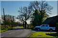
2
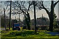
Pilning : Pilning Street
Looking along Pilning Street.
Image: © Lewis Clarke
Taken: 14 Mar 2022
0.19 miles
3
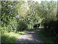
Riding on Gumhurn Lane
Hidden among willows, the lane crosses a drainage channel before joining Pilning Street.
Image: © Robin Stott
Taken: 13 Sep 2011
0.19 miles
5
Pilning : Pilning Street
Looking along Pilning Street.
Image: © Lewis Clarke
Taken: 14 Mar 2022
0.19 miles
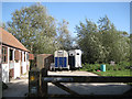
6
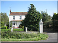
Rosemont, Pilning Street
Appears coterminous with Pilning Farm; shows signs of homage to the horse. A windy day.
Image: © Robin Stott
Taken: 13 Sep 2011
0.19 miles
7
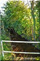
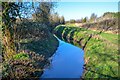
Pilning : Gumhurn Rhine
Looking along the small stream.
Image: © Lewis Clarke
Taken: 14 Mar 2022
0.20 miles
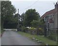
8
Pilning : Gumhurn Lane
A small lane heads off from Pilning Street.
Image: © Lewis Clarke
Taken: 14 Mar 2022
0.20 miles
9
Pilning : Gumhurn Rhine
Looking along the watercourse.
Image: © Lewis Clarke
Taken: 14 Mar 2022
0.20 miles
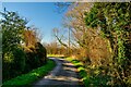
10
Rookery Lane
The western end of Rookery Lane, near to the junction with Pilning Street.
Image: © Ruth Riddle
Taken: 13 Jun 2012
0.21 miles