IMAGES TAKEN NEAR TO
Madison Way, BRISTOL, BS35 4ER
Introduction
This page details the photographs taken nearby to Madison Way, BS35 4ER by members of the Geograph project.
The Geograph project started in 2005 with the aim of publishing, organising and preserving representative images for every square kilometre of Great Britain, Ireland and the Isle of Man.

There are currently over 7.5m images from over14,400 individuals and you can help contribute to the project by visiting https://www.geograph.org.uk
Image Map
Images are licensed for reuse under creativecommons.org/licenses/by-sa/2.0
Notes
- Clicking on the map will re-center to the selected point.
- The higher the marker number, the further away the image location is from the centre of the postcode.
Image Listing (6 Images Found)
Images are licensed for reuse under creativecommons.org/licenses/by-sa/2.0
Image
Details
Distance
1
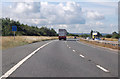
M49 southbound
About 3 miles to the M5 junction. At marker 4.0
Image: © Julian P Guffogg
Taken: 9 Aug 2013
0.10 miles
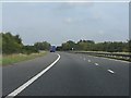
5
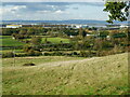
The industrial landscape around the M49
Viewed from Spaniorum Hill.
Image: © Neil Owen
Taken: 15 Oct 2020
0.21 miles
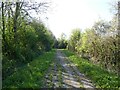
6
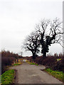
End of the road
This road used to go to Vimpenny's Common according to the 1940's OS Map, now the M49 blocks the way and Vimpenny's Common is no longer there. The M49 is on the horizon.
Image: © Linda Bailey
Taken: 7 Feb 2006
0.22 miles