IMAGES TAKEN NEAR TO
Russet Close, BRISTOL, BS35 4EF
Introduction
This page details the photographs taken nearby to Russet Close, BS35 4EF by members of the Geograph project.
The Geograph project started in 2005 with the aim of publishing, organising and preserving representative images for every square kilometre of Great Britain, Ireland and the Isle of Man.

There are currently over 7.5m images from over14,400 individuals and you can help contribute to the project by visiting https://www.geograph.org.uk
Image Map
Images are licensed for reuse under creativecommons.org/licenses/by-sa/2.0
Notes
- Clicking on the map will re-center to the selected point.
- The higher the marker number, the further away the image location is from the centre of the postcode.
Image Listing (27 Images Found)
Images are licensed for reuse under creativecommons.org/licenses/by-sa/2.0
Image
Details
Distance
1
Stone Stile, Olveston GS9523
On Gloucestershire footpaths OOL/35/40 & OOL/35/30 looking NW. The view SE is Image
Image: © Mr Red
Taken: 22 May 2023
0.12 miles
2
Stone Stile, Olveston GS9523
On Gloucestershire footpaths OOL/35/40 & OOL/35/30 looking SE. The view NWis Image
Image: © Mr Red
Taken: 22 May 2023
0.12 miles
3
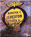
Old AA and Motor Union winged badge on Haw Lane, Olveston
Old winged badge on a house on the south side of Haw Lane, Olveston, in parish of Olveston (South Gloucestershire District), 3 miles Southwest of Thornbury.
This is the winged badge, not circular, but similar to car badge, erected by AA and Motor Union at bottom, 1910 type, showing distances Alveston 2 Redwick 3½ London 129¼. Not visible on Google Street View.
There were five series of AA signs, mostly dating from 1923 and made by Francis & Co / Franco in Deptford, London. The village name and distance to London or Dublin were normally displayed. Information on the Motor Union of Great Britain and Ireland is here https://www.gracesguide.co.uk/Motor_Union_of_Great_Britain_and_Ireland.
Milestone Society National ID: GL-OLV
Image: © Milestone Society
Taken: Unknown
0.12 miles
5
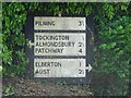
Old Roadsign, Haw Lane, Olveston
Direction sign on the Southern side of the road. Aust was significant as a ferry route to Wales
Inscription: Pilning 3¾ // Tockington ½ / Almondsbury 2½ / Patchway 4 // Elberton 1 / Aust 2¼
Milestone Society National ID: tbc
Image: © Mr Red
Taken: 22 May 2023
0.20 miles
6
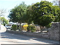
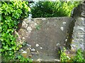
The Elms on The Street
A view along the main road through Olveston: an old stone pillar is kept in the wall. See Image] for a closer look at the old benchmark on it.
Image: © Neil Owen
Taken: 28 Mar 2019
0.21 miles
7
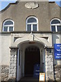
Olveston's Methodist chapel
Originally a Wesleyan Methodist chapel, this place of worship carries on today with a toddlers' group. The date stone bears the date 1820.
Image: © Neil Owen
Taken: 28 Mar 2019
0.21 miles
8
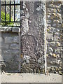
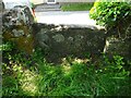
Benchmark on The Street
An old stone pillar remains in among the newer wall. The benchmark is listed in the Benchmark Database: https://www.bench-marks.org.uk/bm106147 . See Image] for a wider view of The Street.
Image: © Neil Owen
Taken: 28 Mar 2019
0.22 miles
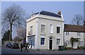
10
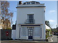
The old Post Office, Olveston
This fine building in the centre of the village was once the Post Office before the duties were transferred to another site around the turn of the 1900s. See Image] for a look at the southern aspect.
Image: © Neil Owen
Taken: 28 Mar 2019
0.22 miles