IMAGES TAKEN NEAR TO
Short Way, BRISTOL, BS35 3UU
Introduction
This page details the photographs taken nearby to Short Way, BS35 3UU by members of the Geograph project.
The Geograph project started in 2005 with the aim of publishing, organising and preserving representative images for every square kilometre of Great Britain, Ireland and the Isle of Man.

There are currently over 7.5m images from over14,400 individuals and you can help contribute to the project by visiting https://www.geograph.org.uk
Image Map
Images are licensed for reuse under creativecommons.org/licenses/by-sa/2.0
Notes
- Clicking on the map will re-center to the selected point.
- The higher the marker number, the further away the image location is from the centre of the postcode.
Image Listing (10 Images Found)
Images are licensed for reuse under creativecommons.org/licenses/by-sa/2.0
Image
Details
Distance
2
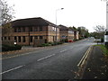
Office buildings by the Thornbury Industrial Estate
On the road which encircles Thornbury to the south.
Image: © David Purchase
Taken: 6 Nov 2016
0.17 miles
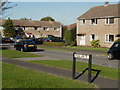
3
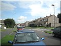
Streamleaze, Thornbury
A residential road some 800m long, curving from south of the town centre to meet Grovesend Road.
Image: © Robin Stott
Taken: 18 Sep 2010
0.19 miles
4
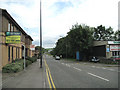
Midland Way heads east
Midland Way is Thornbury's southern perimeter road. It is built on part of the dismantled branch line between Thornbury and Yate. There is a large industrial estate to the south (right), offices and residential areas to the north.
Image: © Robin Stott
Taken: 18 Sep 2010
0.19 miles
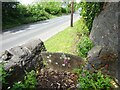
8
Stone Stile, Thornbury
This view is from the B4061, Bristol Road, the view looking back is Image A pedestrian entrance to a small group of houses.
Image: © Mr Red
Taken: 17 May 2022
0.23 miles
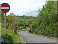
9
Stone Stile, Thornbury
This view is looking to the B4061, Bristol Road, the view looking back is Image A pedestrian entrance to a small group of houses.
Image: © Mr Red
Taken: 17 May 2022
0.23 miles
10
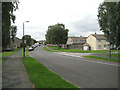
West end of Streamleaze, Thornbury
Streamleaze is a residential road some 800m long, curving from south of the town centre to meet Grovesend Road. The view in the opposite direction, from the next square, is Image
Image: © Robin Stott
Taken: 18 Sep 2010
0.25 miles