IMAGES TAKEN NEAR TO
Clay Lane, BRISTOL, BS35 3UA
Introduction
This page details the photographs taken nearby to Clay Lane, BS35 3UA by members of the Geograph project.
The Geograph project started in 2005 with the aim of publishing, organising and preserving representative images for every square kilometre of Great Britain, Ireland and the Isle of Man.

There are currently over 7.5m images from over14,400 individuals and you can help contribute to the project by visiting https://www.geograph.org.uk
Image Map
Images are licensed for reuse under creativecommons.org/licenses/by-sa/2.0
Notes
- Clicking on the map will re-center to the selected point.
- The higher the marker number, the further away the image location is from the centre of the postcode.
Image Listing (13 Images Found)
Images are licensed for reuse under creativecommons.org/licenses/by-sa/2.0
Image
Details
Distance
1
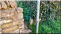
Stone Stile, Thornbury GS9527
On Gloucestershire footpaths OTH/35 & OTH/35 looking NE from Clay Lane, the view to the road is Image
Image: © Richard Laycock
Taken: 19 Apr 2021
0.01 miles
2
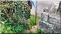
Stone Stile, Thornbury GS9527
On Gloucestershire footpaths OTH/35 & OTH/35 looking SE to Clay Lane, the view from the road is Image
Image: © Richard Laycock
Taken: 19 Apr 2021
0.01 miles
3
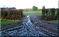
A muddy field entrance, Woodbine Farm east of Thornbury
Viewed from Hackett Lane.
Image: © Jaggery
Taken: 2 Jan 2012
0.14 miles
4
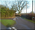
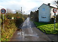
Clay Lane, The Hackett near Thornbury
Opposite St Paul's church, http://www.geograph.org.uk/photo/3394836 Clay Lane heads north away from a grass triangle
at the junction with Hackett Lane.
Image: © Jaggery
Taken: 2 Jan 2012
0.16 miles
5
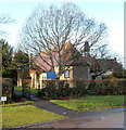
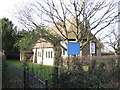
St Paul's Church, The Hackett near Thornbury
The Church of England church is in the parish of St Mary the Virgin, Thornbury.
Viewed from the junction of Hackett Lane and Clay Lane in a semi-rural location east of Thornbury.
Image: © Jaggery
Taken: 2 Jan 2012
0.17 miles
6
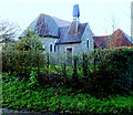
St Paul's Church, The Hackett near Thornbury
The Church of England church is in the parish of St Mary the Virgin, Thornbury.
Viewed from Hackett Lane in a semi-rural location east of Thornbury.
http://www.geograph.org.uk/photo/3394836 to another view.
Image: © Jaggery
Taken: 2 Jan 2012
0.17 miles
7
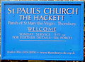
Name board, St Paul's Church, The Hackett near Thornbury
The board is at the entrance here. http://www.geograph.org.uk/photo/3394836
Image: © Jaggery
Taken: 2 Jan 2012
0.17 miles
9
Hackett Lane, Thornbury
The 40mph speed limit along Morton Way behind the camera
reduces to 30mph along the lane to The Hackett.
Image: © Jaggery
Taken: 2 Jan 2012
0.20 miles
10
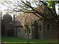
St Paul's church, The Hackett
On the edge of the dormitary town of Thornbury.
Image: © Jonathan Billinger
Taken: 15 Jan 2007
0.20 miles