IMAGES TAKEN NEAR TO
Holly Close, BRISTOL, BS35 3PW
Introduction
This page details the photographs taken nearby to Holly Close, BS35 3PW by members of the Geograph project.
The Geograph project started in 2005 with the aim of publishing, organising and preserving representative images for every square kilometre of Great Britain, Ireland and the Isle of Man.

There are currently over 7.5m images from over14,400 individuals and you can help contribute to the project by visiting https://www.geograph.org.uk
Image Map (Loading...)


Getting Data...Please wait
Leaflet Map data © OpenStreetMap
Images are licensed for reuse under creativecommons.org/licenses/by-sa/2.0
Notes
- Clicking on the map will re-center to the selected point.
- The higher the marker number, the further away the image location is from the centre of the postcode.
Image Listing (29 Images Found)
Images are licensed for reuse under creativecommons.org/licenses/by-sa/2.0
Image
Details
Distance
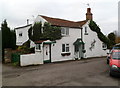
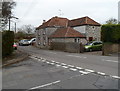
2
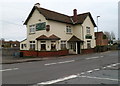
The Cross Hands of Alveston
Pub located at the staggered crossroads of Vattingstone Lane, The Down, Down Road and Strode Common. A representation of a real ale barrel is fixed to a corner of the pub at upstairs level.
The pub has a purpose-built floodlit petanque area, used by the South Gloucestershire Petanque League which run matches from April-September. Petanque is played with metal boules. Each player has two boules, which are thrown with the aim of landing as near to the jack as possible.
The pub is also the home venue of the Severn Vale Crib Team. Crib(bage) is a card game.
Image: © Jaggery
Taken: 27 Dec 2011
0.13 miles
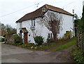
3
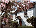
White Cottage, The Square, Alveston
This picture appeared in Thornbury Gazette.
Image: © Michael Elcock
Taken: Unknown
0.14 miles
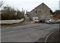
4
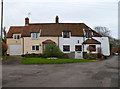
Two cottages and a hand pump, Alveston
Located on the corner of The Square and Wolfridge Lane. In front of the cottages is a black hand-operated water pump.
Image: © Jaggery
Taken: 27 Dec 2011
0.14 miles
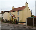
5
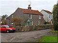
17 The Square, Alveston
This is one of the dwellings in The Square, a group of houses and cottages built mainly in the mid nineteenth century.
Image: © Jaggery
Taken: 27 Dec 2011
0.14 miles
6
White Cottage, 10 The Square, Alveston
Located in the SW corner of the Square, viewed across Wolfridge Lane. The cottage was originally a dressmaker's workroom, for the lady who lived in the cottage on the camera side of the lane.
Image: © Jaggery
Taken: 27 Dec 2011
0.14 miles
7
Wye Cottage, The Square, Alveston
The cottage is located on the west side of The Square, a group of houses and cottages built mainly in the mid nineteenth century.
Image: © Jaggery
Taken: 27 Dec 2011
0.14 miles
8
Corner of Wolfridge Lane and Wolfridge Ride, Alveston
A view south along Wolfridge Lane from Wolfridge Ride.
Wolfridge Lane was mentioned in a Saxon charter as a boundary between the parishes of Alveston and Olveston.
Image: © Jaggery
Taken: 27 Dec 2011
0.15 miles
9
The Old Smithy, Alveston
Located on The Down, viewed from the corner of Wolfridge Ride.
The Old Smithy, now a private residence, was formerly one of 5 smithies in the village. A smithy is a blacksmith’s workshop.
Image: © Jaggery
Taken: 27 Dec 2011
0.15 miles
10
The Old Bakery, Alveston
Now a private residence, 13 The Down, this was the village bakery and shop until 1984. A lozenge showing 1870 is embedded in the wall above the doorway.
Image: © Jaggery
Taken: 27 Dec 2011
0.18 miles