IMAGES TAKEN NEAR TO
Downfield Close, BRISTOL, BS35 3NJ
Introduction
This page details the photographs taken nearby to Downfield Close, BS35 3NJ by members of the Geograph project.
The Geograph project started in 2005 with the aim of publishing, organising and preserving representative images for every square kilometre of Great Britain, Ireland and the Isle of Man.

There are currently over 7.5m images from over14,400 individuals and you can help contribute to the project by visiting https://www.geograph.org.uk
Image Map
Images are licensed for reuse under creativecommons.org/licenses/by-sa/2.0
Notes
- Clicking on the map will re-center to the selected point.
- The higher the marker number, the further away the image location is from the centre of the postcode.
Image Listing (37 Images Found)
Images are licensed for reuse under creativecommons.org/licenses/by-sa/2.0
Image
Details
Distance
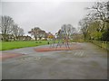
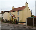
2
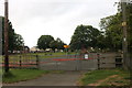
Playground on The Down, Alveston
Currently closed for covid lockdown
Image: © David Howard
Taken: 23 May 2020
0.07 miles
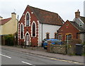
3
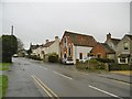
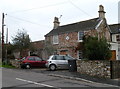
Alveston, Old Chapel
Former chapel on The Down; dated 1883. Old OS maps show this as a Methodist chapel; now residential.
Image: © Mike Faherty
Taken: 19 Mar 2017
0.08 miles
4
22 The Square, Alveston
The Square is a group of houses and cottages built mainly in the mid nineteenth century. The stone inscription in a lozenge above the doorway at 22 The Square is R.A 1837.
1837 was the year of the accession of Queen Victoria on the death of King William IV.
Image: © Jaggery
Taken: 27 Dec 2011
0.08 miles
5
SE corner of Stoney Stile Road, Alveston
Viewed across a road named The Down.
Image: © Jaggery
Taken: 27 Dec 2011
0.08 miles
6
Beech Leaze, Alveston
Viewed from the corner of Stoney Stile Road.
Image: © Jaggery
Taken: 27 Dec 2011
0.09 miles
7
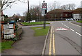
Old-style sign, The Down, Alveston
The sign is at street level at the northern end of The Down, at the edge of The Cross Hands. http://www.geograph.org.uk/photo/2743835
The sign originally showed Aust Ferry but Ferry has been overpainted.
The Aust Ferry formerly operated across the River Severn in Gloucestershire between Aust and Beachley. The nearest fixed Severn crossing was at Gloucester, about 25 miles NE of the ferry.
The last ferry crossing was on September 8th 1966. The Severn Bridge opened the next day.
Image: © Jaggery
Taken: 27 Dec 2011
0.09 miles
8
The Old Bakery, Alveston
Now a private residence, 13 The Down, this was the village bakery and shop until 1984. A lozenge showing 1870 is embedded in the wall above the doorway.
Image: © Jaggery
Taken: 27 Dec 2011
0.09 miles
9
The Old Chapel, Alveston
Now a dwelling, number 15 The Down was formerly a chapel. The year 1883 is inscribed in the stonework at the top of the central window.
Image: © Jaggery
Taken: 27 Dec 2011
0.09 miles