IMAGES TAKEN NEAR TO
Vattingstone Lane, BRISTOL, BS35 3LA
Introduction
This page details the photographs taken nearby to Vattingstone Lane, BS35 3LA by members of the Geograph project.
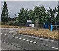
The Geograph project started in 2005 with the aim of publishing, organising and preserving representative images for every square kilometre of Great Britain, Ireland and the Isle of Man.

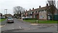
There are currently over 7.5m images from over14,400 individuals and you can help contribute to the project by visiting https://www.geograph.org.uk
Image Map
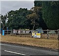
Images are licensed for reuse under creativecommons.org/licenses/by-sa/2.0
Notes
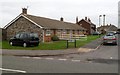
- Clicking on the map will re-center to the selected point.
- The higher the marker number, the further away the image location is from the centre of the postcode.
Image Listing (26 Images Found)
Images are licensed for reuse under creativecommons.org/licenses/by-sa/2.0
Image
Details
Distance
1
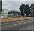
School scaffolding, Alveston, South Gloucestershire
Scaffolding is on Marlwood School in late July 2022.
Viewed across Vattingstone Lane.
Image: © Jaggery
Taken: 24 Jul 2022
0.03 miles
2
Marlwood School, Alveston
Set back from Vattingstone Lane (B4461) in the west of Alveston. Marlwood is a mixed comprehensive school for pupils aged 11-18. There are about 1,200 pupils enrolled, of which about 200 are in the sixth form. The school has been on this site since it became a comprehensive in 1972.
Image: © Jaggery
Taken: 27 Dec 2011
0.03 miles
3
Marlwood secondary school, Vattingstone Lane, Alveston
Image: © Roger Cornfoot
Taken: 28 Mar 2007
0.04 miles
4
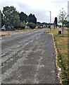
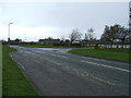
Vattingstone Lane, Alveston, South Gloucestershire
Looking to the SE along Vattingstone Lane from a parking area in July 2022.
Image: © Jaggery
Taken: 24 Jul 2022
0.05 miles
5
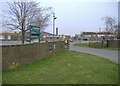
Quarry Road, Alveston
This is the SW side of Quarry Road, viewed from Vattingstone Lane (B4461). The far end of Quarry Road connects with Down Road. There were formerly several quarries in Alveston. All have been built over.
Image: © Jaggery
Taken: 27 Dec 2011
0.06 miles
6
Quarry Road bungalows, Alveston
A row of 4 bungalows is at the Vattingstone Lane (B4461) end of Quarry Road.
Image: © Jaggery
Taken: 27 Dec 2011
0.06 miles
7
Banner on a school perimeter fence, Alveston, South Gloucestershire
Viewed across Vattingstone Lane in July 2022. Text on the banner outside Marlwood School includes "HANDS" "FACE" "SPACE".
Image: © Jaggery
Taken: 24 Jul 2022
0.06 miles
8
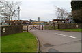
School entrance, Alveston, South Gloucestershire
Viewed across Vattingstone Lane. Vehicles enter the Marlwood School site on the right and exit the site behind the camera. In July 2022 a sign shows a 5mph speed limit in the school grounds.
Image: © Jaggery
Taken: 24 Jul 2022
0.08 miles
9
Vehicular entrance to Marlwood School
The main entrance to Marlwood School's grounds is located near to the caretakers' cottage on the site.
Image: © Ruth Riddle
Taken: 24 Dec 2011
0.08 miles
10
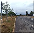
Parking area, Vattingstone Lane, Alveston, South Gloucestershire
Opposite Marlwood School.
Image: © Jaggery
Taken: 24 Jul 2022
0.08 miles